
Mountain Thunderstorms
2017-07-14 17:25:31.000 – Nicole Tallman, Summit Intern
Let’s set the scene: It is a beautiful day in the valley with blue skies, calm winds, and warm temperatures. You and some friends happily decide to take a hike up to the summit of Mount Washington. Your hike begins fantastically with beautiful conditions but the closer you get to your destination the more the weather is changing and the clouds are beginning to appear, some looking more ominous and darker than others. Why is it that in the mountains clouds and thunderstorms tend to appear out of thin air? How could these clouds and storms appear when it was such a beautiful day in the valley?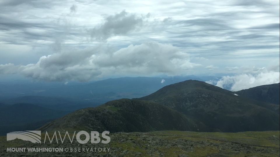
Let’s take a look at how storms and clouds can form in the mountains. Thunderstorms form when moist, unstable air near the surface is lifted. Mountain regions can aid in the formation of thunderstorms by several terrain induced mechanisms (Whiteman, 114). The most important mechanism for Mount Washington being orographic lift. This is when air is forced to rise over a surface and this rising can induce cloud formation as well as a potential thunderstorm. Clouds are formed when the relative humidity of an air parcel reaches 100%, or in other words, the air temperature and dew point are equal. In a mountain terrain, air rises buoyantly above the summits, cooling as it ascends. When the air cools to its dew point, temperature water droplets begin to form and clouds will arise. The droplets will continue to ascend and cool even more. Some droplets will freeze and grow by taking the water from other cloud droplets. As these frozen particles grow and become too heavy for the cloud they will begin to fall, colliding with other particles as they fall which can create electrical charges within the cloud and lead to lightning (Bishop,2).
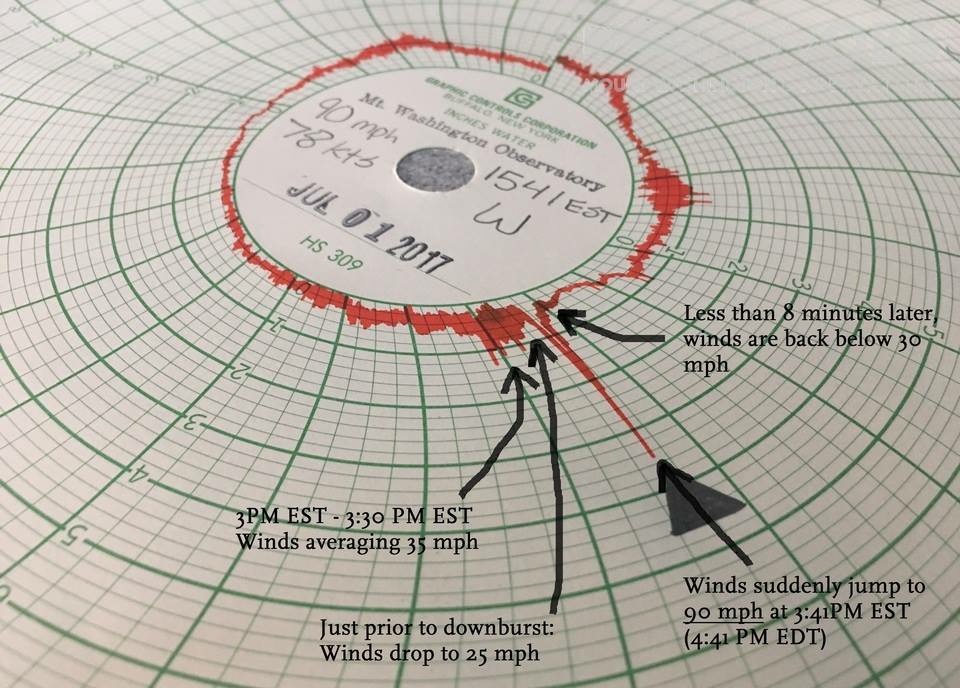
It is very important to be prepared for the weather wherever you are. However, because mountain weather is subject to rapid change and may be very different than the valley weather, you should always check the forecasts before entering the mountains. While being on the summit I have been lucky enough to see two thunderstorms. The most intense of the two was on my first day as an intern. This storm lived up to its expectations and brought hail, rain, 60 mph winds and lightning! Since the summit is the highest point in the area and has metal towers near our building we do see direct lightning strikes to the building when thunderstorms come about. The second thunderstorm I was able to experience was on my last shift. This thunderstorm brought a lot of excitement when a downburst came right over the summit. A downburst is an area of strong downward flowing air within a thunderstorm that can result in heavy rains and winds. We experienced a large increase in the intensity of our rain and winds maxing out at 90 mph. I had never experienced a downburst before so this was very exciting. Having the winds fluctuate from 25 mph all the way to 90 mph and then back down is a very good example of just how fast the weather can change.
References:
Bishop, Jim. Mountain Thunderstorms Their Formation and Some Field-Forecasting Guidelines. , 2007
Whiteman, Charles David. Mountain Meteorology: Fundamentals and Applications. New York: Oxford UP, 2000
Nicole Tallman, Summit Intern

Seek the Peak Spotlight: The Cloud Chasers
Seek the Peak Spotlight: The Cloud Chasers By MWOBS Staff Mike Bergeron and Desiree Bolton have been participating and volunteering for Seek the Peak for three years now. Together, they comprise Team Cloud Chasers

Celebrating 250 Years: The Declaration’s Legacy in the White Mountains
Celebrating 250 Years: The Declaration's Legacy in the White Mountains By Peter Crane We are now approaching July Fourth, Independence Day, the day when we celebrate the adoption of the Declaration of Independence in

Seek the Peak Spotlight: Ryan Shepard
Seek the Peak Spotlight: Ryan Shepard By MWOBS Staff Before Ryan Shepard moved to Conway, he was in Western New York celebrating his 40th birthday party. “I wanted to go big,” he said. “Big”
