No Granite on the Top of The Granite State?
2022-09-09 12:33:54.000 – Hayden Pearson, Weather Observer & Research Specialist
While New Hampshire is known as The Granite State, there is actually no granite to be found on the summit of Mount Washington. This is a common misconception by many who visit New England’s highest peak. The majority of the bedrock that visitors see is in fact a Devonian metamorphic schist and quartzite of the Littleton Formation.
This formation started out as eroded mud and sand deposits, at the bottom of an ancient ocean, which were then metamorphosed into the rock we see today.
So how did material that was on the bottom of an ocean end up on the top of a mountain? To fully understand where these rocks came from, we have to unravel a bit of the complicated geologic history of the White Mountains and how they were formed.
 This plate tectonic cross-section depicts the forming of the Presidential Mountains starting ~420 million years ago with the deposition of marine sediment (Eusden 2010).
This saga started about 425 million years ago with two prehistoric oceans, the Kronos and Rheic Oceans. These separated the Laurentia tectonic plate from the Avalon plate and the Avalon plate from the Gondwana plate. High amounts of erosion transported rocks and sediment from these ancient tectonic plates to the bottom of the oceans until about 410 million years ago. It is these sediment deposits that would become the summit of Mount Washington.
As the Laurentia and Avalon plates moved, they closed off the ancient oceans, trapping this sediment between them before colliding. The immense heat and pressure that comes from the collision of the tectonic plates turned this sediment into schist and quartzite.
The Acadian Collision, the event that caused the metamorphism, occurred roughly 390 million years ago, deforming the rock. This deformation came from the active thrust fault, the process by which one tectonic plate rides up over the other, very much in the same way that the Himalayas are formed today. This collision would have created a mountain range at least 15,000 feet tall, rivaling the heights of the Rocky Mountains!
The view of the ancient Presidential Range, ~400 million years ago, as viewed from the west. This is compared to today’s skyline (Eusden 2010).
While tectonic plates continued to collide over the next 100 million years to form Pangea and the remainder of the Appalachian Mountains, no significant mountain building occurred in New England during this time. It wasn’t until the opening of the Atlantic Ocean, roughly 180 million years ago during the Triassic period, when there was a lot of volcanism that occurred within New Hampshire from plate subduction as the ocean grew. As the ocean spread, it pushed material down under the mountain range where heating from the mantle melted the rock and allowed it to work its way to the surface of Earth’s crust.
Due to erosion, not much igneous rock remains from this period in geologic history. Rock formations from this time can most easily be seen in both Tuckerman and Huntington Ravines, where meter-wide basalt dikes – large intrusions of igneous rock – ascend areas around the headwalls. While still grand, the Presidential Range has undergone a lot of mountain building and erosion in its nearly 400 million years of existence, a lot of which occurred from being covered by the Laurentide Ice Sheet during the Last Glacial Maximum ending roughly 12,000 years ago. That, however, is a story for a different day.
Timeline of mountain building and erosion events that caused the creation of the Presidential Mountain Range (Eusden 2010).
If you happen to be traveling up to the higher summits this summer and want to know more, NEIGC published a comprehensive
roadside guide to the geology as you ascend Mount Washington.
Was there ever granite on Mount Washington? Maybe. Granite metamorphoses into granitic gneiss. Granite is a phaneritic intrusive igneous rock, so at some point, since there are other igneous depositions found, there could have been granite on the summit in the distant past. There are some bits of granite if you look at a geologic map of the area, but they are not on the summit, nor on most of the White Mountain summits. Granite erodes easier than the schists that are left, and during glacial events, large amounts of material were removed from the mountains, so there are some gaps in the geologic stratigraphy.
Figures courtesy of J. Eusden at Bates College.
References
Eusden, J. “The Presidential Range: Its Geologic and Tectonic History” Department of Geology, Bates College. 2010.
Eusden, J. & Anderson, Brigit & Castro, Carlos & Gardner, Patrick & Guiterman, Christopher & Higgins, Stephanie & Kugel, Kelley & Reid, Adam & Rodda, Charles & Tamposi, Caitlin. (2017). Bedrock Geology of Mt. Washington, Presidential Range, NH. 177-196. 10.26780/2017.001.0011. 2017
Hayden Pearson, Weather Observer & Research Specialist

 This plate tectonic cross-section depicts the forming of the Presidential Mountains starting ~420 million years ago with the deposition of marine sediment (Eusden 2010).
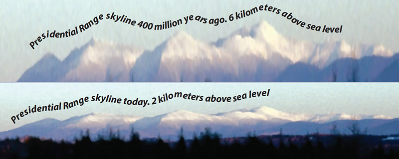 The view of the ancient Presidential Range, ~400 million years ago, as viewed from the west. This is compared to today’s skyline (Eusden 2010).
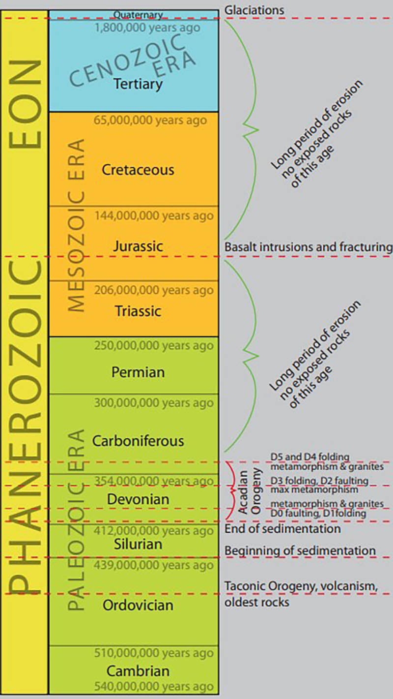 Timeline of mountain building and erosion events that caused the creation of the Presidential Mountain Range (Eusden 2010).


