
NULL
2006-05-19 11:49:09.000 – Jim Salge, Observer

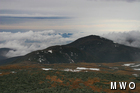
A spring landscape…a dwindling snowpack!
In a brief break in the incessant clouds yesterday, we were able to scan the landscape, and specifically note how it has changed in the past 9 days of fog and rain. For snow lovers, the scene is not good! The remaining snow pack has been eaten away by the fog, now only residing on the usual late season snowfields, and very few other soon to melt patches remain. Even comparing pictures to previous years, the Jefferson Snow Patch, which can last until August, is looking mighty thin!
It is perhaps strange to point out then, that we have lost this tremendous amount of snow pack in temperatures that have remained below normal so far this month, mainly remaining in the low to mid 30s. The culprit is actually the persistent fog of the past few weeks. Fog acts as an insulating blanket, which doesn’t allow the snow pack to radiate heat, and thus the entire snow pack remains warmer and melts faster.
It is likely that tonight, the melting will cease for at least a little while. This will not be because of any reprieve in the fog…but because temperatures will drop below freezing and new snow will likely fall. Accumulations should be minor, but it’s always neat to see a return to fresh white this time of year!
Jim Salge, Observer

Seek the Peak Spotlight: The Cloud Chasers
Seek the Peak Spotlight: The Cloud Chasers By MWOBS Staff Mike Bergeron and Desiree Bolton have been participating and volunteering for Seek the Peak for three years now. Together, they comprise Team Cloud Chasers

Celebrating 250 Years: The Declaration’s Legacy in the White Mountains
Celebrating 250 Years: The Declaration's Legacy in the White Mountains By Peter Crane We are now approaching July Fourth, Independence Day, the day when we celebrate the adoption of the Declaration of Independence in

Seek the Peak Spotlight: Ryan Shepard
Seek the Peak Spotlight: Ryan Shepard By MWOBS Staff Before Ryan Shepard moved to Conway, he was in Western New York celebrating his 40th birthday party. “I wanted to go big,” he said. “Big”
