
NULL
2006-05-18 07:54:13.000 – Jim Salge, Observer

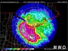
Radar estimates from the last storm
More rain (and a little wet snow) continues to impact the peak this morning. In the last 24 hours we have picked up another half inch of rain bringing our monthly total to 10.38 inches. This number however is remarkably low compared with areas just south of us, all the way down through Massachusetts where they are dealing with historic flooding.
The picture at right shows the radar estimates for rainfall totals for the past week’s storm from the NWS radar in Gray, ME. The widespread 8 to 12 inch totals across the state are incredible to see, but I’m more drawn to the aberrations around, and specifically to the West of Mount Washington. The wedge of low totals west of Mount Washington have two causes, one real, one a figment of the technology used in the estimate.
The first and most apparent reason for the low precip wedge west of the peak is a phenomenon called beam blockage. The radar beam leaves Gray, ME, and performs numerous scans of the horizon at different angles to get its radar imagery. However, when the scan is performed on its lowest tilt, the beam actually hits our mountain somewhere just above treeline. Therefore the radar beam is actually blocked from recording low precipitation west of the mountain.
The second reason for the wedge, and more specifically the reduced rainfall totals west of the mountains, is down sloping. The rain that fell from this storm formed in very low clouds that were moving from east to west. As the storm clouds trekked from the ocean to the mountains, they lost much of their moisture as rainfall. Therefore, once the air rose over the peak, and descended the other side of the White Mountains, there was very little moisture left to fall as rain. The observers during the storm even observed a lot of clear air on the western slopes during the event, while the rest of the mountain was socked in!
The result of these two phenomena is the wedge of low precip and beam blockage extending from Mount Washington in today’s picture. By comparison, here is a map of the event storm totals, this time hand drawn from actual observation data points around New England. Much better!
The rain today is much different in nature than this past week, as it is moving west to east, and is forming much higher up in the clouds. But that doesn’t make it any less wet, and we would love a break on the peak from all this dreary weather. Doesn’t look like we’ll get one any time soon!
Jim Salge, Observer

Seek the Peak Spotlight: The Middleton Family
Seek the Peak Spotlight: The Middleton Family By MWOBS Staff Every summer, the White Mountains offer no shortage of reasons to get outside. Trails stretch in every direction—endless miles of terrain, summits that each
Lots of Digging, but Never Enough
Lots of Digging, but Never Enough By Ryan Tanski Over the past four months, I had the privilege of working with the Mount Washington Avalanche Center and Mount Washington Observatory, deepening my understanding of

Saying Goodbye to the Summit
Saying Goodbye to the Summit By Anna Trujillo It's hard to believe that my time on the summit is already coming to an end. Over the past several months I have learned so much
