
NULL
2006-05-14 14:46:49.000 – Neil Lareau, Observer

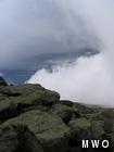
Contrast
Fleeting glimpses of the sun, mostly seen as a diffuse disk through thinning cloud, has broken the monotony of four days of fog. Low stratocumulus are racing up and over the summits leaving an occasional opening on the down slope side to the northwest. Through this window the tops of the low clouds are white set against a rich grey of water laden mid level clouds. The sky is, as a whole, chaotic with clouds at all levels. Lenticulars to the northwest, ragged cumulus below, gaps of blue to the north and east. But not the blue normally associated with sky blue, a richer and peculiar blue that plays off the leaden grey that frames it. In spots altocumulus and patches of cirrus are flat white and nearly featureless. On the rocks, recently liberated rock tripe flutters in the wind. Map lichen shines green. The sedge is rust colored and vivid, almost red in spots. A few weeks ago it was still a desiccated pale brown and blonde. Yesterday and this morning the new richer colors could be seen through the clear glaze ice resulting from hours of rain.
The wind has now been from the southeast for 110 hours, so much for the prevailing Westerlies. The result has been an extreme rain event across much of New Hampshire.
Fog: When you spend four days in the fog you begin to discern differences between types of fog. On Wednesday, the clouds droplets were mammoth. Visible to the naked eye as a granular texture suspended within the medium of air and giving presence to the berserk character of the wind. Then it would start raining or drizzling. The cloud droplets would instantly diminish becoming nearly invisible. Visibility would improve from 50 feet to 1/8 of a mile. The rain droplets in essence grow at the expense of the cloud droplets. Today the fog is thick but the droplets tiny. You couldn’t get wet in this fog if you tried. In fact the deck that had been a puddle strewn expanse is now dry despite the persistence of fog.
Neil Lareau, Observer

Celebrating 250 Years: The Declaration’s Legacy in the White Mountains
Celebrating 250 Years: The Declaration's Legacy in the White Mountains By Peter Crane We are now approaching July Fourth, Independence Day, the day when we celebrate the adoption of the Declaration of Independence in

Seek the Peak Spotlight: Ryan Shepard
Seek the Peak Spotlight: Ryan Shepard By MWOBS Staff Before Ryan Shepard moved to Conway, he was in Western New York celebrating his 40th birthday party. “I wanted to go big,” he said. “Big”

From Florida Heat to the Rockpile
From Florida Heat to the Rockpile By Alek Libby Hi everyone! My name is Alek Libby, and I am one of the summit interns here at Mount Washington Observatory this summer! I recently graduated
