NULL
2011-01-15 14:11:03.000 – Stacey Kawecki, Observer and Meteorologist
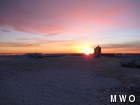
another sunrise!
As I mentioned in yesterday’s comment, we in fact, did get a sunrise this morning! Many of you know to get two sunrises and two sunsets in a row is quite the treat!
One of the coolest things about working/living on a mountain is that oftentimes, you can see the weather coming at you. Sometimes it happens quickly – You see a cloud one minute and you’re in the fog the next. Other times, the weather will slowly approach from the west (or sometimes the southeast).
Something I almost always observe is the cloud progression of a warm front. Ever since my professor of Weather Systems mentioned it, I’ve been fascinated by it. With an approaching warm front, warmer air rides up and over cooler air that is at the surface. The result of this phenomenon, called over-running, is that the air moistens and warms from the top down. High clouds, starting as wispy cirrus clouds, will overspread the sky, becoming a thick layer of cirro-stratus. The next layer of clouds will start to spread out, consisting of thickening alto-stratus. Finally, the lower clouds will advance upon the region, usually bringing steady rain or snow.
Today we got to see the clouds increase overhead as a wall of virga approached. Early in the day, the snow on Whiteface was crystal clear. However, upon looking out the window around noon, the Green Mountains were shrouded by a veil of virga. Soon after, Moosilauke was no longer visible, and by observation time, not even the Franconia Range was visible. It has since begun to lightly snow. Seeing what I learned in a classroom in real life never gets old!
Stacey Kawecki, Observer and Meteorologist
Three and a Half Months of Snow, Ice and Rime
Three and a Half Months of Snow, Ice and Rime, with Deeper Drifts. By Ryan Steinke Me outside on the summit near the Yankee Building. My internship with the Mount Washington Observatory
Supporter Spotlight: Righteous Vices Coffee Roasters
Supporter Spotlight: Righteous Vices Coffee Roasters By MWOBS Staff Righteous Vices Coffee Roasters, a local coffee roaster and shop located in Center Conway, New Hampshire, has been a partner of the Observatory since 2024.
Winter Storm Tracks Across New Hampshire
Winter Storm Tracks Across New Hampshire By Alex Branton As winter comes to a close, most of us are ready for the warmer temperatures and sunshine that come with Spring and Summer. Although we


