NULL
2010-11-07 22:34:04.000 – Mike Carmon, Staff Meteorologist
Orange Sky at Night…Observers Take Flight?
The winds of change are coming once again!
Our last few shifts have seemed to be a story of extremes. Last shift was a prime example, when temperatures bottomed out in the mid single digits near the halfway point of the week, but warmed into the 50s and completely consumed the snow pack in time for our departure.
The established snow pack dwindled once again as temperatures skyrocketed into the mid 40s earlier this shift, only three degrees shy of a record high. But it seems the exposure of the rocks atop the Rockpile will be short-lived, as this latest storm promises to dump a decent amount of snow and ice on us.
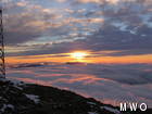
Our past two days have been an absolute pleasure weather wise, with temperatures in the mid 20s, light winds, generally sunny skies, and a very tenacious undercast. However, I awoke today to strikingly ominous skies off to the east as our culprit system neared the New England coastline. It is a bit unconventional, as storm systems, generally speaking, swing in from the west or up the coast from the south. Nevertheless, overhead clouds continued to increase during the afternoon and evening hours, producing a colorfully-dazzling show at sunset time.
As I compose these conservative comments, the radar is alive and well with loads of greens, whites, and oranges (rain, snow, and wintry mix, respectively) bound inland towards New Hampshire. The precipitation is clearly visible in the not-so distance, engulfing the scant sets of city lights one by one from coast to summit. I expect snow will begin to descend within the next hour or so, coupled with a return of the main culprit responsible for the isolated environment that is summit of Mt. Washington–fog. Winds are also expected to make quite an impression, surpassing hurricane force by morning. With anticpated temperatures right around freezing for most of tomorrow and tomorrow night, a major glaze ice event looks to be in the works.
Time to bust out the snow pants, winter boots, goggles, and heavy gloves!
Observer Note: With a significant glaze ice event a distinct possibility tomorrow and tomorrow night, our internet connection may very well be compromised. Hence, if you notice a lack of updates/data on our website during this time, it is most likely because glaze ice has accrued on our microwave dish and interrupted our signal to the valley. Please be sure, if this occurs, we will attempt to rectify the situation in an expedient manner. Thanks for your patience and understanding ahead of time!
Mike Carmon, Staff Meteorologist
Three and a Half Months of Snow, Ice and Rime
Three and a Half Months of Snow, Ice and Rime, with Deeper Drifts. By Ryan Steinke Me outside on the summit near the Yankee Building. My internship with the Mount Washington Observatory
Supporter Spotlight: Righteous Vices Coffee Roasters
Supporter Spotlight: Righteous Vices Coffee Roasters By MWOBS Staff Righteous Vices Coffee Roasters, a local coffee roaster and shop located in Center Conway, New Hampshire, has been a partner of the Observatory since 2024.
Winter Storm Tracks Across New Hampshire
Winter Storm Tracks Across New Hampshire By Alex Branton As winter comes to a close, most of us are ready for the warmer temperatures and sunshine that come with Spring and Summer. Although we


