
NULL
2010-10-26 23:26:02.000 – Mike Carmon, Staff Meteorologist
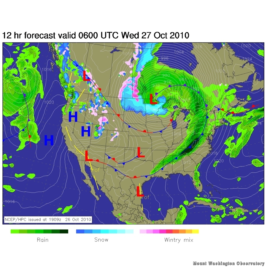
The Massive Cyclone
Meteorologists are known for getting excited over strange occurrences–thunderstorms, high winds, heavy snow, etc. Today is no exception. The entire meteorological community, in addition to residents of the entire eastern half of the continental US, have turned their eyes towards a mid-latitude cyclone currently barreling its way northeastward through the center of the country.
At the time this comment is being written, approx. midnight EDT, the massive low pressure system is positioned over northern Minnesota. However, its effects are hardly limited to its center, as its influence is being felt from eastern Montana to the eastern seaboard.
Here’s a rundown of some of the severe and diverse weather watches this storm has prompted:
Blizzard Warnings across most of North Dakota.
Winter Storm Warnings in northern Minnesota.
Storm Warnings for Lake Michigan, most of Lake Superior, half of Lake Huron.
High Wind Warnings across the northern Great Plains and upper Midwest.
Tornado Watches for the interior mid-Atlantic and southern Appalachian Mountains.
Wind gusts approaching 60 mph are possible across the Great Plains and Midwest, with gusts closing in on the 70 mph mark along the shores of the Great Lakes.
A squall line producing severe thunderstorms and tornadoes is currently running from upstate New York down to Georgia, and will continue to push eastward tonight and tomorrow. Tornadoes have been reported in Illinois, Wisconsin, and Kentucky already.
As of 11AM CDT this morning, this storm achieved a minimum central pressure of 28.41 inches, or 962 mb. This ranks as the second lowest pressure ever witnessed in a Great Lakes storm, behind a mark of 28.05 inches (950 mb) during the Great Blizzard of 1978.
This center of this storm will trek northward into Canada tomorrow, sparing the eastern seaboard the worst it has to offer. That’s a scary thought, considering thunderstorms and possible tornadoes could still be experienced in these locations!
As this storm lifts off to the north and leaves the U.S. in the dust, a chillier air mass will rush in to replace the above-average temperatures that have gripped the east over the past few days. Temperatures will steadily decline over the next couple of days, with the core of the chilly air not arriving until sometime on Friday. So don’t worry winter-fans…this storm will signal a return of more winter-like conditions!
Mike Carmon, Staff Meteorologist

Seek the Peak Spotlight: The Cloud Chasers
Seek the Peak Spotlight: The Cloud Chasers By MWOBS Staff Mike Bergeron and Desiree Bolton have been participating and volunteering for Seek the Peak for three years now. Together, they comprise Team Cloud Chasers

Celebrating 250 Years: The Declaration’s Legacy in the White Mountains
Celebrating 250 Years: The Declaration's Legacy in the White Mountains By Peter Crane We are now approaching July Fourth, Independence Day, the day when we celebrate the adoption of the Declaration of Independence in

Seek the Peak Spotlight: Ryan Shepard
Seek the Peak Spotlight: Ryan Shepard By MWOBS Staff Before Ryan Shepard moved to Conway, he was in Western New York celebrating his 40th birthday party. “I wanted to go big,” he said. “Big”
