
Our scene yesterday
2011-05-28 16:17:50.000 – Ryan Knapp, Staff Meteorologist

This is what I mean by “beautifully ominous”.
Ominous: Giving the impression that something bad or unpleasant is going to happen; threatening; inauspicious.
Beautiful: Delighting the senses of exciting intellectual or emotional admiration.
Beautifully Ominous: Delighting the senses while giving the impression that something bad or unpleasant is going to happen.
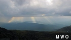
Alright, so that last definition isn’t technically in the dictionary but it was what came to mind yesterday afternoon. Like Brian mentioned in yesterday’s comment, my forecast of being in the fog was incorrect as the cloud layer lifted a few hundred feet above the summit exposing us to the outside world. While this allowed us to get out and enjoy the day it also allowed us to take in the chaotic skies that arrived during the afternoon. A band of showers and thunderstorms moved through Grafton and Coos counties making for a dynamic scene around the summits for several hours around sunset on Friday.
Although we couldn’t make out the tops of the cumulonimbus clouds producing the unsettled weather, we were able to see several other things beneath the sea of clouds. Underneath each cell, a wall of rain poured down like a thick, dark gray curtain highlighted on its edges by the warm glow of the sun. Embedded in each wall of rain, several lightning strikes could be seen. Most were of the cloud to ground variety but intermittently we would see some cloud to cloud activity and occasional cloud to air type strikes as they webbed out and frolicked under the see of stratus clouds around the summit. As each cell moved away, the humid air left in their wake would allow several crepuscular rays to highlight the horizon. Where these rays struck the earth, little wisps of fog would momentarily pop up only to dissipate seconds later as the clouds above changed where the little heavenly spotlights were aiming. And then as one cell departed, the next cell would move in to start to the cycle all over again.
So ahead of each cell there would be a scene of beauty but the further south your eyes traveled, the ominous skies of the impending storm would soon take over. It was a lot to take in and process and it all quickly filled a large chunk on my memory card as my camera was continuously snapping away the quickly changing scenery. Eventually, the humidity levels rose and fog once again obscured our vistas. But while it lasted, it was fun to see and something I was glad I was up here to witness.
Ryan Knapp, Staff Meteorologist

Seek the Peak Spotlight: Ryan Shepard
Seek the Peak Spotlight: Ryan Shepard By MWOBS Staff Before Ryan Shepard moved to Conway, he was in Western New York celebrating his 40th birthday party. “I wanted to go big,” he said. “Big”

From Florida Heat to the Rockpile
From Florida Heat to the Rockpile By Alek Libby Hi everyone! My name is Alek Libby, and I am one of the summit interns here at Mount Washington Observatory this summer! I recently graduated
Summit Summer
Summit Summer By Aspen M. Hello everyone! My name is Aspen, I’m one of the summer weather interns here at the Mount Washington Observatory. I fell in love with weather at a young age
