Record Breaking Temperatures
2018-09-17 12:57:41.000 – Zach Butler, Summit Intern
As I typed this, we were breaking a daily record high temperature on Mount Washington! The temperature was 62 degrees, which broke the record for the 15th all the way back to 1939 when they recorded a temperature of 61. What lead up to these warm temperatures the other day and back in 1939? How do the days compare to each other? I went to the weather maps and history books to find out.
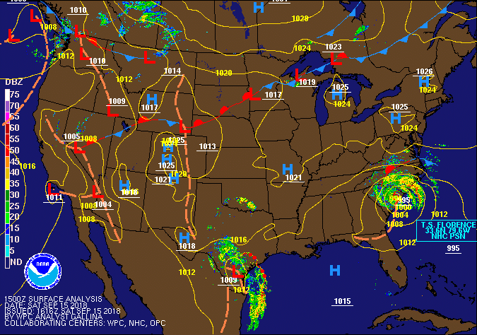
The weather pattern for New England was a large upper level ridge with a strong surface high pressure that had been stationary the last several days. This high pressure brought extremely nice weather to the higher summits with few clouds, little to no wind, and warm temperatures.

From this surface map, you can see the surface high pressure centered over New England. The main weather event was Tropical Storm Florence in the Carolina’s. This strong high pressure is part of the reason Florence had been slowly moving down West.
The most remarkable aspect about the high pressure over the White Mountains was the weak pressure gradient causing very light winds atop Mount Washington. The 3 days before the record break had observed wind speeds of less than 20 mph during the day, even being calm at times. While this can happen atop the summit, it is rare to see these low wind speeds for such a long and consistent duration. These weak wind speeds allowed temperatures to warm on the summit significantly. Usually, wind is able to reduce temperatures by literally blowing them off the summit. But with these calm winds, the warm temperatures were sticking right on the summit, allowing us to hit 62. The day before, we actually tied the daily record high of 60 back in 1993 and 2017.
So, did the weather patterns that day consist of similar conditions back in 1939 with the previous record of 61? I went back to the Observatory’s log books to compare the days. Below you see an image of the hand written log from September 15th, 1939.

Wow, what a difference in days! From observations on Septemebr 15th, 1939; the summit was in the clouds for most of the day with sustained westerly winds from 20-40 mph. After 12pm however, they broke out of the clouds. By 3pm, the sky cover was only a 2, which means there were only a few clouds in the sky. This break in the clouds allowed the temperature to increase to previous record of 61 degrees.
With partial clouds, the temperature stayed between 60 and 61 degrees until evening. This clearing in the clouds decreased winds slightly, in the range of the 20-35 mph. Despite the winds and clouds in the sky, temperatures were able to warm to 61 degrees.
This is a quite a difference in weather conditions compared to 2 days ago, with little to no clouds and wind. While there are no archived surface maps to see what kind of air mass was over the region in 1939, they did record the pressure in the log books. 24.118 inches of mercury was recorded on the summit that day. 2 days ago the barometric pressure was at 24.136 in hg. These two pressure readings are fairly similar. Therefore, back in 1939, there was likely a high pressure system over the summit. This high pressure system was likely associated with more moisture, causing more clouds on the summit. This could have been combined with a tighter pressure gradient in the high pressure back in 1939, that would lead to faster wind speeds compared to the other day.
This short analysis shows the differences of weather conditions that can lead to warm temperatures. It was very interesting to check out some of the Observatory’s old weather observations to compare to the 15ths record breaking readings!
Zach Butler, Summit Intern
Three and a Half Months of Snow, Ice and Rime
Three and a Half Months of Snow, Ice and Rime, with Deeper Drifts. By Ryan Steinke Me outside on the summit near the Yankee Building. My internship with the Mount Washington Observatory
Supporter Spotlight: Righteous Vices Coffee Roasters
Supporter Spotlight: Righteous Vices Coffee Roasters By MWOBS Staff Righteous Vices Coffee Roasters, a local coffee roaster and shop located in Center Conway, New Hampshire, has been a partner of the Observatory since 2024.
Winter Storm Tracks Across New Hampshire
Winter Storm Tracks Across New Hampshire By Alex Branton As winter comes to a close, most of us are ready for the warmer temperatures and sunshine that come with Spring and Summer. Although we


