
Science, Weather and Ice
2015-10-23 19:31:58.000 – Michael Dorfman, Weather Observer/IT Specialist
We’ve had quite a temperature swing in the last 24 hours! We went from close to the 40 degree mark to 14 degrees in less than 12 hours! Yesterday I was comfortable in a light summer jacket, but I was forced to put on my thick powerstretch Eastern Mountain Sports long underwear (I call it my blubber). The wintry weather made for some of the most significant rime ice growth so far this winter for my shift.
The rime ice made really interesting patterns on our observation deck. Every year when riming season starts, I ponder why some of these patterns might exist. For example, we see several inches of rime ice growth around the leading edges of the pavers that cover our observation deck, but little to no rime ice on the flat surfaces on top of the pavers. We often see more rime ice growth on the northwest corner of our observation deck than anywhere else, with daggers sometimes growing 2 feet off the deck!
Why does ice grow in such strange ways? In order to answer this question, we must first know how this ice forms. Fog is made up of minute water particles floating through the air. Whenever the summit is in the fog and below freezing (about 60 percent of the year), these droplets are supercooled, and freeze instantaneously on contact with any surface. The faster these droplets are propelled into a surface, the faster they accrue into rime ice. The cracks between the pavers on the deck offer an area of turbulence where the supercooled fog droplets impact more frequently. In the northwest corner of the deck, air jumps over the railing, and then dives down onto the deck making impact with much more force than other parts of the deck.
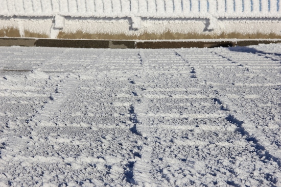 Rime Ice Growth on the Observation Deck Pavers
Some people confuse rime and glaze ice with freezing rain. These aren’t raindrops though – the smaller the droplet is, the more easily it travels around an object. That means that most of the drops miss the objects they’re aiming for – they simply are pushed to the side by the pressure wave created by the object. And that’s definitely a good thing; rime ice growth rates would increase if that weren’t the case. How much more? Let’s do some math. Skip down two paragraphs if you don’t enjoy math.
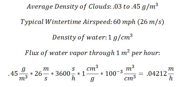
Before I dig too deep into equations, I must say this is a brief informal analysis of conditions on the summit. According to a 2007 study (“Simulating the Adiabatic Ascent of Atmospheric Air Parcels using the Cloud Chamber) , as well as Wikipedia, cloud densities range between .03 and .45 g/m2. We can use this with the wind speed on the summit to determine average flux (total amount of liquid) passing through a square meter every hour.
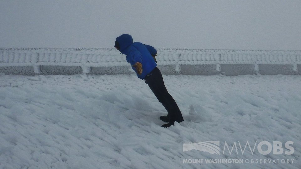 While this may not look like a lot of rime ice, these ice formations are nearly parallel with the ground, extending 1-2 feet in length!
As you can tell, I’m thoroughly enjoying the rime ice conditions here on the summit. Unfortunately, we’ll definitely see some melting in the next couple of days, but this warmth will only be brief. Winter is here to stay on the summit, so if you do plan to venture to the summit, be sure to check the Higher Summits Forecast!
Michael Dorfman, Weather Observer/IT Specialist

Celebrating 250 Years: The Declaration’s Legacy in the White Mountains
Celebrating 250 Years: The Declaration's Legacy in the White Mountains By Peter Crane We are now approaching July Fourth, Independence Day, the day when we celebrate the adoption of the Declaration of Independence in

Seek the Peak Spotlight: Ryan Shepard
Seek the Peak Spotlight: Ryan Shepard By MWOBS Staff Before Ryan Shepard moved to Conway, he was in Western New York celebrating his 40th birthday party. “I wanted to go big,” he said. “Big”

From Florida Heat to the Rockpile
From Florida Heat to the Rockpile By Alek Libby Hi everyone! My name is Alek Libby, and I am one of the summit interns here at Mount Washington Observatory this summer! I recently graduated
