
Severe Weather
2013-11-18 17:34:29.000 – Samuel Hewitt, Summit Intern
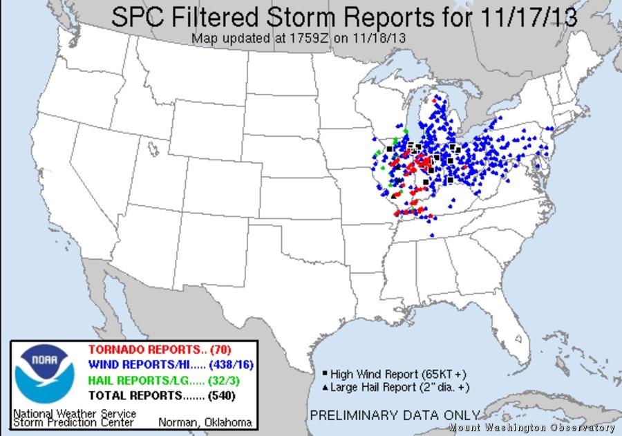
11-17-13 Storm Reports courtesy NWS SPC
Yesterday’s severe weather outbreak across the Midwest/Ohio River Valley will go down as one of worst in recorded history for the month of November. Preliminary reports from the National Weather Service indicate that more than 70 tornadoes touched down across six states, the majority of which occurred in Illinois and Indiana. The most prominent tornado was a violent EF-4 (winds 166-200 mph) that passed through the town of Washington in Tazewell County, IL. Records show that this is the first EF-4 to strike Tazewell County since at least 1950.
Statistically speaking, Illinois receives 1 tornado per year on average in the month of November. The hotspot for November tornadoes is in Dixie Alley (LA, AR, MS, TN, AL, GA, western FL), where 33 tornadoes occur per year on average in November across the seven state region. This was the site of the most significant November outbreaks in recorded history, which occurred from the 21st-23rd of 1992. There were 105 tornadoes and 26 people lost their lives.
This event is a reminder that cold season tornado outbreaks can occur. Generally speaking, the instability needed for thunderstorm development is heavily reliant on how much daytime heating a region sees (the more the better). In yesterday’s case, marginal heating (temperatures 60 to around 70 Fahrenheit) was enough to produce thunderstorms. What set this event aside from a typical late spring/early summer one was the significant amount of wind shear that was present in the atmosphere. The shear compensated for the lack of heating to produce nearly 70 tornadoes. It is hard to believe that just one week ago, this region was blanketed with 0.5 inches of snow!
This same system crossed New England early this morning, producing heavy rain showers and a few rumbles of thunder. On the summit, we received 1.01″ of rain and winds gusted to 97 mph. Our thoughts and prayers are with all those affected by yesterday’s tornadoes.
Samuel Hewitt, Summit Intern

Seek the Peak Spotlight: The Cloud Chasers
Seek the Peak Spotlight: The Cloud Chasers By MWOBS Staff Mike Bergeron and Desiree Bolton have been participating and volunteering for Seek the Peak for three years now. Together, they comprise Team Cloud Chasers

Celebrating 250 Years: The Declaration’s Legacy in the White Mountains
Celebrating 250 Years: The Declaration's Legacy in the White Mountains By Peter Crane We are now approaching July Fourth, Independence Day, the day when we celebrate the adoption of the Declaration of Independence in

Seek the Peak Spotlight: Ryan Shepard
Seek the Peak Spotlight: Ryan Shepard By MWOBS Staff Before Ryan Shepard moved to Conway, he was in Western New York celebrating his 40th birthday party. “I wanted to go big,” he said. “Big”
