
Snow, Snow, Snow
2013-12-27 12:43:36.000 – Mike Carmon, Weather Observer/Education Specialist
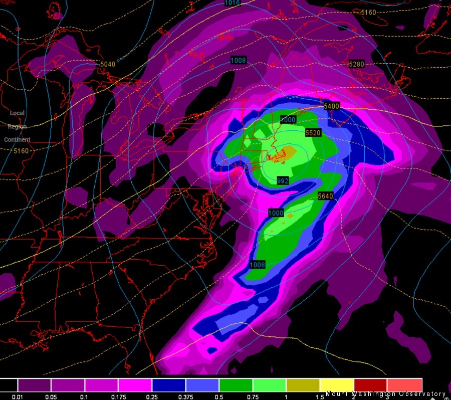
Sunday Night’s Possible Culprit
The snow machine has cranked!
We received 6.6 inches of snow yesterday from the Clipper system that passed over the region, with another .7 inches falling overnight. Since the departure of that storm, the flow has shifted around to the west, which has combined with a passing upper-level trough to produce ideal upslope snow conditions. As a result, snow has continued to fall throughout this morning, with gusty west winds creating incredibly poor visibility (no more than 25 feet all morning).
After this round of snow has abated, the next one will be right on its heels! A coastal system has revealed itself in the computer models for Sunday night and early Monday, which has the possibility to blossom into a significant Nor’easter. The models are in pretty good agreement right now, but a slight wobble in the projected path of this storm could make a huge difference (3-6 inches vs. 12-15 inches). For now, we’ll have to wait and see!
Mike Carmon, Weather Observer/Education Specialist

Seek the Peak Spotlight: The Cloud Chasers
Seek the Peak Spotlight: The Cloud Chasers By MWOBS Staff Mike Bergeron and Desiree Bolton have been participating and volunteering for Seek the Peak for three years now. Together, they comprise Team Cloud Chasers

Celebrating 250 Years: The Declaration’s Legacy in the White Mountains
Celebrating 250 Years: The Declaration's Legacy in the White Mountains By Peter Crane We are now approaching July Fourth, Independence Day, the day when we celebrate the adoption of the Declaration of Independence in

Seek the Peak Spotlight: Ryan Shepard
Seek the Peak Spotlight: Ryan Shepard By MWOBS Staff Before Ryan Shepard moved to Conway, he was in Western New York celebrating his 40th birthday party. “I wanted to go big,” he said. “Big”
