
Springtime Hazards
2009-04-24 16:30:03.000 – Brian Clark, Observer and Meteorologist

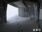
Lots of snow + lots of wind = big drifts
This time of year can be a particularly dangerous one on Mount Washington. Not necessarily just because of the harshness of the weather on the summit, but even more because of the drastic difference between the weather in the valley and the weather on the summit, as well as how quickly things can go from tranquil and spring-like to ferocious mid-winter conditions and back again. The weather over the last few days, as well as the next couple days ahead, demonstrates this very well.
Wednesday saw some clearing and very calm winds during the morning and early afternoon hours with temperatures in the mid to low 30’s. By the same time on Thursday, snow was falling and winds had increased to above hurricane force. Temperatures had also dropped to a chilly (for this time of year) 20 degrees. A big contrast to the 40’s and 50’s with rain showers in the valley at the same time. Now today we are back to warmer temperatures and calmer winds.
During this last storm we measured a total of 13.8 inches of snow on the summit. That much snow coupled with the high winds yesterday (we had a peak gust of 118 mph) was able to transport a lot of snow. The USFS snow rangers forecasted a ‘high’ avalanche danger yesterday; today was rated ‘moderate’ and ‘considerable’.
Of course all that winter weather will be quick to forget this weekend when temperatures on the summit soar into the 50’s with plenty of sunshine, bringing a new set of hazards to the droves of people that are sure to flock to the mountain for skiing and hiking adventures this weekend. Wet snow avalanches will be a concern in steep terrain as the newly deposited slabs of snow warm very quickly. Also the usual spring icefall hazard will be even more of a concern than usual. All these hazards and more are discussed by our friends, the USFS snow rangers, in their daily avalanche report, which can be found on our website as well as their official site. Be sure to check that out before you head to the mountain this weekend, and be safe out there!
Brian Clark, Observer and Meteorologist

Seek the Peak Spotlight: The Cloud Chasers
Seek the Peak Spotlight: The Cloud Chasers By MWOBS Staff Mike Bergeron and Desiree Bolton have been participating and volunteering for Seek the Peak for three years now. Together, they comprise Team Cloud Chasers

Celebrating 250 Years: The Declaration’s Legacy in the White Mountains
Celebrating 250 Years: The Declaration's Legacy in the White Mountains By Peter Crane We are now approaching July Fourth, Independence Day, the day when we celebrate the adoption of the Declaration of Independence in

Seek the Peak Spotlight: Ryan Shepard
Seek the Peak Spotlight: Ryan Shepard By MWOBS Staff Before Ryan Shepard moved to Conway, he was in Western New York celebrating his 40th birthday party. “I wanted to go big,” he said. “Big”
