
Squall vs. Microburst: What’s the Difference?
2018-09-07 11:10:13.000 – Thomas Padham, Weather Observer/Education Specialist
Earlier today I received a weather question which I thought would make for a great blog post. What’s the difference between a squall and a microburst?
A squall sort of has two meanings, the meteorological definition (which we use for our reporting) and the term used by everyday people. The National Weather Service definition of a squall is: “A strong wind characterized by an increase in wind speed of at least 16 knots and sustained at 22 knots or greater for more than a minute”. As you can see that’s quite specific, and something we rarely report from the summit since we actually see conditions meeting this definition very often. We use our discretion as to whether the increase in wind is operationally significant, and also have the option of reporting a “peak gust” in our hourly observations for winds under 100 mph, with a mandatory peak gust reported for all winds over 100 mph.
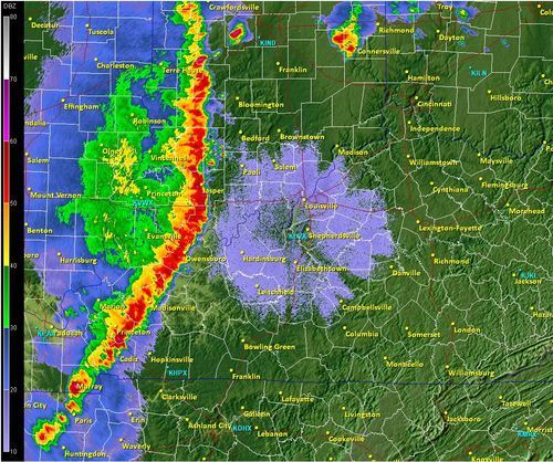
To most people, a squall (or squall line) is a heavy band of showers, possibly containing rain or snow. The band may also be accompanied by lightning, and is always accompanied by suddenly strong and gusty winds as the NWS definition states. Personally, I tend to think of the term “snow squall” which can occur during the winter here in the Northeast typically with an arctic cold front. These have heavy, but usually brief snow along with gusty winds and create whiteout conditions and hazardous travel.
A microburst has similar weather conditions to that of a squall, and may actually occur within a squall line from thunderstorms. A microburst is a sudden and rapid increase in wind speed from rain cooled air within or around a thunderstorm. This mass of colder air descends from a thunderstorm, picking up speed and spreading out as it hits the ground. This can occur over a small and localized area, hence the prefix micro. If conditions are right these downdrafts of higher winds can occur over much larger areas, and are typically referred to as a “macroburst”. Long-lived damaging wind storms, crossing several hundred miles and lasting for many hours are called derechos.
A microburst can sometimes see wind speeds in excess of 100 mph, with similar damage to that of a tornado. The damage will actually look different from that of a tornado in that the wind pattern spreads out over an area (similar to dumping a bucket of water onto the ground) vs. a tornado will have a rotating wind/damage pattern.
Thomas Padham, Weather Observer/Education Specialist

Seek the Peak Spotlight: The Cloud Chasers
Seek the Peak Spotlight: The Cloud Chasers By MWOBS Staff Mike Bergeron and Desiree Bolton have been participating and volunteering for Seek the Peak for three years now. Together, they comprise Team Cloud Chasers

Celebrating 250 Years: The Declaration’s Legacy in the White Mountains
Celebrating 250 Years: The Declaration's Legacy in the White Mountains By Peter Crane We are now approaching July Fourth, Independence Day, the day when we celebrate the adoption of the Declaration of Independence in

Seek the Peak Spotlight: Ryan Shepard
Seek the Peak Spotlight: Ryan Shepard By MWOBS Staff Before Ryan Shepard moved to Conway, he was in Western New York celebrating his 40th birthday party. “I wanted to go big,” he said. “Big”
