
Stormy Weather
2013-06-29 18:53:32.000 – Mike Dorfman, Weather Observer

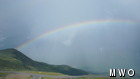
A Pot of Gold at Nelson Crag?
What a better time for lightning week than this week? Sandwiched between a high pressure system offshore, spinning clockwise, and a low pressure system to our northwest, spinning counterclockwise, the northeast is getting a direct shot of maritime air. A southwesterly flow is allowing extremely humid air to flow through the northeast.
June is also the time of year when the sun is highest in the sky and strongest. As sunlight warms up the surface of the earth during the day, the warm air near the surface will bubble up and rise into the atmosphere. As this air rises, it cools, and cooler air cannot hold as much gaseous water as warm air. Once it reaches a certain temperature, the air becomes saturated and forms a cloud.
At this point, many different factors come into play as to whether or not a thunderstorm will form. The basic concept is the same concept behind a rising hot air balloon. This area, also called a parcel, of air only rises while is it warmer than the air around it. As air condenses and a cloud forms, however, it releases more heat, warming even more. With very large thunderstorms, this air rises to a point high in our atmosphere called the tropopause. The unique characteristic of this section of our atmosphere is that it becomes warmer with height. As a rising cloud reaches this layer, surrounding temperatures will become closer to the temperature of the cloud, and the cloud will stop rising. Since the top of this cloud has nowhere higher to rise, it flattens out at this level. This is the ultimate “cap” for extremely convective storms and is the reason for the anvil shape seen on large cumulonimbus clouds.
The current setup, with extremely humid air and strong daytime heating, is very supportive for thunderstorm formation. Combine that with both a low pressure system to our east and several frontal boundaries going through the northeast, and widespread afternoon thunderstorms are a daily occurrence.
So, if you’re hiking outside in the next few days, be extremely mindful that a fun, partly cloudy morning can quickly turn into a dangerous, stormy afternoon! In the spirit of lightning safety week, get informed and visit the National Weather Service’s special lightning safety page.
Mike Dorfman, Weather Observer

Seek the Peak Spotlight: The Cloud Chasers
Seek the Peak Spotlight: The Cloud Chasers By MWOBS Staff Mike Bergeron and Desiree Bolton have been participating and volunteering for Seek the Peak for three years now. Together, they comprise Team Cloud Chasers

Celebrating 250 Years: The Declaration’s Legacy in the White Mountains
Celebrating 250 Years: The Declaration's Legacy in the White Mountains By Peter Crane We are now approaching July Fourth, Independence Day, the day when we celebrate the adoption of the Declaration of Independence in

Seek the Peak Spotlight: Ryan Shepard
Seek the Peak Spotlight: Ryan Shepard By MWOBS Staff Before Ryan Shepard moved to Conway, he was in Western New York celebrating his 40th birthday party. “I wanted to go big,” he said. “Big”
