The Anything-But Calm Before the Storm!
2019-02-11 08:31:34.000 – Chloe Boehm, Summit Intern
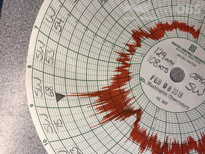
The summit this weekend saw a pretty incredible wind event with a peak gust of 148 mph. Although the highest winds were on Saturday, Friday morning saw the most dramatic increase in wind speed. The winds jumped from 45 mph to 124 mph in just 7 minutes! For those of us working in the weather room, it seemed to come out of nowhere! One minute we could barely hear the wind at all, and the next, a roar of wind erupted.

(Picture of the wind gust on the Hays chart)
While the winds were impressive, what was almost equally impressive was the temperature change that was experienced at all elevations. Up on the summit we saw a temperature spike of almost two degrees while the base of the Auto Road (1600 ft) saw a temperature spike of about 7 degrees! The plots below give a visual representation of those temperature spikes.
This event was mostly likely caused by a downburst which accompanied the passage of the cold front. These downbursts are a sudden burst of wind towards the surface that commonly occur in rainstorms or thunderstorms. Although there was no thunder present at the summit, there was heavy rain. Since there was a cold front moving into the area there was warm air aloft, so as that air rushed towards the ground, so did a lot of warm air. This then caused the temperature spike both at the summit and the base. Another factor that is indicative of the incoming cold front is that before the downburst, the base was actually colder than the summit. The base temperature was hovering right around 30 degrees where the summit was right around 32 degrees. This layer of warmer air led to this temperature inversion and later resulted in freezing rain.
What started out as a moderate wind day Friday morning, quickly escalated, giving a good indication of what was to come!
Chloe Boehm, Summit Intern
Three and a Half Months of Snow, Ice and Rime
Three and a Half Months of Snow, Ice and Rime, with Deeper Drifts. By Ryan Steinke Me outside on the summit near the Yankee Building. My internship with the Mount Washington Observatory
Supporter Spotlight: Righteous Vices Coffee Roasters
Supporter Spotlight: Righteous Vices Coffee Roasters By MWOBS Staff Righteous Vices Coffee Roasters, a local coffee roaster and shop located in Center Conway, New Hampshire, has been a partner of the Observatory since 2024.
Winter Storm Tracks Across New Hampshire
Winter Storm Tracks Across New Hampshire By Alex Branton As winter comes to a close, most of us are ready for the warmer temperatures and sunshine that come with Spring and Summer. Although we


