
The Strange Clouds of Mount Washington
2017-06-09 17:10:14.000 – Margaret Jividen, Summit Intern
Any weather watcher, whether a professional or just someone who enjoys following along as an enthusiast, is familiar with the common cloud types identified by meteorologists. They are categorized by shape and base height, using Latin derived names such as cumulus meaning ‘heap’ or cirrus meaning ‘hair.’ These naming standards were first developed as early as 1802 by English meteorologist Luke Howard. The majority of common cloud types became standardized by the end of the 19th century. Weather observers at the summit continuously monitor the skies and take note of any interesting or unique cloud formations.
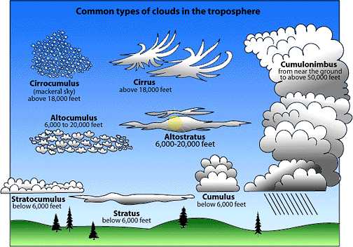
Figure 1: Chart of common cloud types, from UCAR Center for Science Education, 2012.
However, as weather observations have become more frequent and advanced in the last several decades, new and strange cloud types have been identified. Many of these extraordinary formations can be seen right here from the summit of Mount Washington.
The most commonly seen of these oddities is a lens shaped cloud known as a lenticular cloud. The lenticular cloud, also known (elevation depending) as stratocumulus, altocumulus, or cirrocumulus lenticularis, often forms around obstructions in the atmosphere, especially mountain ranges. As stable, moist air flows over a boundary (such as the White Mountains), the protrusion of the boundary causes turbulence. Waves caused by these disturbances, will form lenticular clouds if the temperature and dew point are equal at the apex of the wave. These clouds are so bizarre that they may be a reason for some UFO reports by uninformed onlookers near mountain ranges.
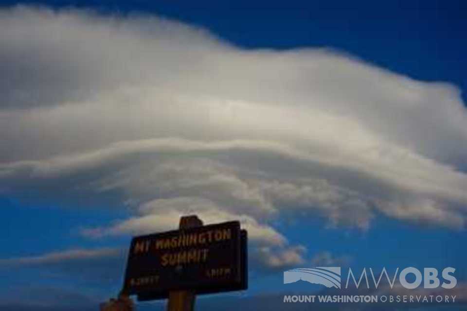
Figure 2: A lenticular cloud seen above the summit sign seen in 2015.
Just this morning, summit staff received a show of another unique cloud attribute classified as asperitas, previously known as undulatus aspertatus. This is one of the newest supplementary cloud features, formally added to the International Cloud Atlas in March 2017. These formations appear to move like waves, undulating overhead as they move through the sky. They are extremely dynamic, and are caused by wind shear at cloud level. While today they were preceding thunderstorms to the summit’s north, these choppy, wavelike clouds are not always seen near to the time of convective activity.
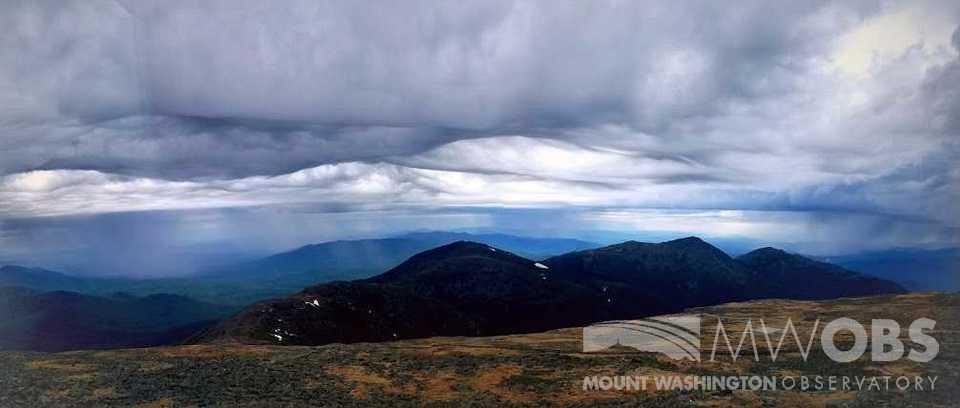
Figure 3: Asperitas clouds seen by summit staff at around 7:30 AM this morning.
Mammatus are another supplementary feature of various cloud types. They are characterized by sacs of cold air hanging off of the base of a cloud. Unlike asperitas, these clouds are often associated with severe weather nearby. They are also associated with extreme vertical gradients of temperature and moisture at cloud height. Both mammatus and asperitas clouds are currently being researched by atmospheric scientist across the world to find out more about what mechanisms generate their formation. We also got to witness the asperatis clouds slowly become mammatus, two rare cloud elements in one day!
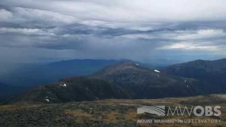
Figure 4: The mammatus clouds are characterized by the pouches of cold air hanging off the base, as seen here today.
The next time you visit the summit, be sure to try to identify the clouds overhead and below. Whether it’s a common fair weather cumulus or one of these unusual sights, remember to appreciate the science and beauty of our atmosphere.
Margaret Jividen, Summit Intern

Seek the Peak Spotlight: The Cloud Chasers
Seek the Peak Spotlight: The Cloud Chasers By MWOBS Staff Mike Bergeron and Desiree Bolton have been participating and volunteering for Seek the Peak for three years now. Together, they comprise Team Cloud Chasers

Celebrating 250 Years: The Declaration’s Legacy in the White Mountains
Celebrating 250 Years: The Declaration's Legacy in the White Mountains By Peter Crane We are now approaching July Fourth, Independence Day, the day when we celebrate the adoption of the Declaration of Independence in

Seek the Peak Spotlight: Ryan Shepard
Seek the Peak Spotlight: Ryan Shepard By MWOBS Staff Before Ryan Shepard moved to Conway, he was in Western New York celebrating his 40th birthday party. “I wanted to go big,” he said. “Big”
