
Unusual Weather Phenomena Photo Gallery – Part 1
2008-05-12 22:33:07.000 – Matthew Morin, Space Grant Intern

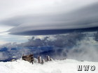
Lenticular Clouds
When I found out that I was going to be an Intern at the Mount Washington Observatory, I thought I knew what to expect weather-wise when it came to high winds, arctic temperatures and loads of snow. Among the traditional cold weather gear needed to be fully prepared for a weeklong stay at the home of the world’s worst weather, I packed my camera with hopes of capturing amazing winter scenery. Sure enough, that’s exactly what I experienced. However, that was the extent of my meteorological expectations. Little did I know that I would get to witness a wide variety of meteorological phenomena that I just happened to learn about in my undergraduate studies.
Currently, I am on my seventh shift up at the Observatory. Over the past few months I’ve taken around 500 pictures which include several different types of optical phenomena and unusual cloud formations. In this Observer Comment, I will show you some of the best of the best in my collection.
Crepuscular Rays:
This optical phenomenon occurs when clouds partially shadow the sun’s rays. We are able to see the unobstructed rays of light due to haze in the atmosphere which scatters visible light toward the observer.
Lenticular Clouds & Cap Clouds:
Perhaps one of the most interesting clouds to view, lenticular clouds, or altocumulus standing lenticularus, form as a result of turbulence caused by air being forced to move up and over mountains. Under stable atmospheric conditions, large-scale standing waves tend to form lee of the mountains. Lenticular clouds may form at the crest of these waves if the air is forced up high enough to cause adiabatic cooling and eventually condensation if there is enough available moisture. Cap clouds form by a similar process with the exception of their location. These types of clouds set up directly over a mountain and do not propagate, thereby capping the mountaintop. The picture I took of a cap cloud is from the perspective of under the cap rather then the traditional distant profile view.
Undercast:
The last picture in Part 1 of my photo gallery is of a very common cloud formation that is seemingly mundane to those who view it from below. However, overcast skies can create a beautiful and awe-inspiring scene given it is below you with clear and sunny skies aloft. An expanse of low stratus clouds that are below the observer’s elevation is referred to as undercast. These clouds are frequently seen at the Mount Washington Observatory due to the station’s elevation 6,300 feet above sea level. Though undercast is a common occurrence up here, it never ceases to amaze me, especially when it is embellished by the warm red-orange glow from a sunset or sunrise.
Stay tuned for part 2 of my Unusual Weather Phenomena Photo Gallery coming soon!
Matthew Morin, Space Grant Intern

Celebrating 250 Years: The Declaration’s Legacy in the White Mountains
Celebrating 250 Years: The Declaration's Legacy in the White Mountains By Peter Crane We are now approaching July Fourth, Independence Day, the day when we celebrate the adoption of the Declaration of Independence in

Seek the Peak Spotlight: Ryan Shepard
Seek the Peak Spotlight: Ryan Shepard By MWOBS Staff Before Ryan Shepard moved to Conway, he was in Western New York celebrating his 40th birthday party. “I wanted to go big,” he said. “Big”

From Florida Heat to the Rockpile
From Florida Heat to the Rockpile By Alek Libby Hi everyone! My name is Alek Libby, and I am one of the summit interns here at Mount Washington Observatory this summer! I recently graduated
