Update on this weekend’s Winter Storm!
2019-01-17 17:33:43.000 – Ian Bailey, Weather Observer/Education Specialist
On Tuesday, Observer Tom Padham wrote about the potential for an impressive winter storm for the Northeast this weekend. Like he said in his blog, we have been following the evolution of the storm so far, as well as what different weather models are indicating for the weekend ahead. Now that we are inside an appropriate 72-hour forecast window, I’d like to update you on how both the atmosphere and the storm of interest have progressed since the last post, and start to give a more concrete forecast for this approaching storm.
To start off the weekend, an upper-level disturbance associated with a shortwave jet stream feature will allow a low pressure system from the South-Central Plains to be drawn rapidly towards the Eastern seaboard. Given the relative West-to-East flow of the lower levels of the atmosphere, it is likely that this low will track a decent distance off shore, before banking left and running a loose parallel to the coast.
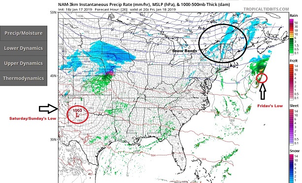
So while the low will not directly impact New England at its maturity, it will bring in a loose plume of moisture from down near the gulf. As this moisture propagates on the backside of the low headed North, it will inevitably produce loose and light bands of snow showers across the Northern part New Hampshire throughout the day on Friday. Accumulation totals across the regions have decreased a bit since Tuesday, and at present only a trace to 1 inch seems possible from these snow bands, Think of it as a very light taste of what’s supposed to come later in the weekend, which you can see forming over Northern Texas in the image below from the NAM 3K model.

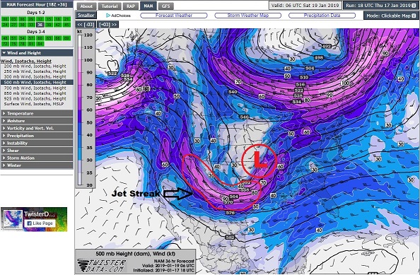
So what happens next and what leads to this big storm headed our way? As it stands, it appears the dispersed energy from a strong low pressure system in the Northwest part of the country will reorganize near the Eastern Colorado border. A steep upper level ridge will build just West of the Rockies, which will allow for strong North-to-South flow that will transport that dispersed energy into the Southern Plains. This in turn will coagulate into a strong Jet Streak, or a high-velocity pocket of air in the upper levels of the atmosphere that generally leads to atmospheric disturbances and the instability necessary to build low pressure systems and develop storms. You can see this strong Jet Streak in the image below, and I’ve also circled where the low is likely to form and build following cyclogenesis on Saturday morning.

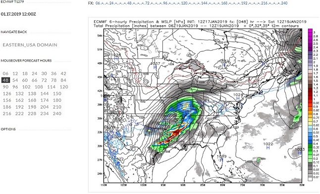
Throughout this entire overnight process, the low is gathering warm, moist air from the Gulf of Mexico to fuel itself before its inevitable march Eastward. And with a number of blocking high pressures to the East and North, the low will continue to remain within striking distance of the Gulf for a significant period. The entire time, the system will be taking in and distributing moisture, building what will likely become a massive moisture plume by the end of the day on Saturday. Below is a picture from the ECMWF model runs of the low pressure on Saturday morning and Saturday evening for comparison.


You may notice that on the evening ECMWF run, the moisture plume has extended to reach the majority of New England. It’s truly impressive that while the center of the system remains in the Mid Atlantic, it has gathered and dispersed enough moisture that it is forecasted to precipitate as far away as Maine at the same time. And at this point, the low is only beginning to reach its point of maturity.
Overnight Saturday and into Sunday, the low will continue to propagate East, dumping large amounts of rain and snow as it moves. After crossing over the Appalachians and reaching the waters of the East coast, the low will ingest more available moisture and reach its peak intensity. And after sunrise on Sunday morning, the center of the low will crash into New England proper, producing some impressive rain and snowfall totals. By the end of the day on Sunday, 1.5 to 2.5 inches of a wintery mix of precipitation could fall across the Southern portions of New England, an approximately 16 inches of snow across the Northern portion where temperatures will likely remain at or below freezing. At the summit, we are even expecting snowfall totals near 20 inches!


Additionally, if we look just outside the forecast window in MLK Day, temperatures are likely to plummet following the low’s associated cold front. Subzero temperatures are not out of the question for most of New England, including New Hampshire, Vermont, Massachusetts and Connecticut. So it certainly has the potential to be a frigid, blustery holiday.
It certainly is a lot to take in. But the takeaway here is that the models agree with the strong potential for a Nor’easter to blast the coast by the end of this weekend. States further South can likely expect heavy amounts of rain and wintery mixes in precipitation, while the Northern states are in for a considerable amount of snow. And in this winter storm’s wake, a brief period of elevated winds and frigid temperatures would be expected; even more so here on the summit of Mount Washington.
Model agreement is high and consistent, NWS offices are putting out Winter Storm Advisories, Watches and Warnings, and with each passing day the atmospheric structure proves to be more and more conducive for a big storm. We will continue to monitor the storm’s progress over the course of the weekend, and will certainly be outside Sunday morning for our Facebook Live update to check it out! It looks like it’s going to be quite exciting, so make sure to stayed tuned in the coming days as we track this impending Nor’easter! And be sure to check out our forecast products on our website for more information!
Ian Bailey, Weather Observer/Education Specialist
Three and a Half Months of Snow, Ice and Rime
Three and a Half Months of Snow, Ice and Rime, with Deeper Drifts. By Ryan Steinke Me outside on the summit near the Yankee Building. My internship with the Mount Washington Observatory
Supporter Spotlight: Righteous Vices Coffee Roasters
Supporter Spotlight: Righteous Vices Coffee Roasters By MWOBS Staff Righteous Vices Coffee Roasters, a local coffee roaster and shop located in Center Conway, New Hampshire, has been a partner of the Observatory since 2024.
Winter Storm Tracks Across New Hampshire
Winter Storm Tracks Across New Hampshire By Alex Branton As winter comes to a close, most of us are ready for the warmer temperatures and sunshine that come with Spring and Summer. Although we


