
Using Clouds to Predict the Future
2018-02-18 17:22:53.000 – Caleb Meute, Weather Observer/Staff Meteorologist
A bout with the influenza virus has kept me sidelined this week and at home in Burlington where Molly has followed me around the house sanitizing with a bottle of lysol, rubber gloves and a mask. It is an unfortunate part of shift work on Mount Washington that when someone gets sick, the rest of the crew continues on, shouldering a bigger workload. To compound matters furthermore, another virus swept through the Observatory and took Adam down as well which has made things unimaginably difficult on our shift leader, Mike. Thankfully, he did his Ron Burgundy impression, polished off the summit Conch Shell and bellowed out for past Observers to assemble, and the legendary Rebecca Scholand answered the call and is helping out until Wednesday. Thanks Becca!
When I am not working on the mountain, I am far less in tune with what is going on weather wise and frequently find myself outside in conditions I am not expecting. This is especially true this week as I have paid absolutely no attention to the weather and more attention to the inside of my eye lids and how much Dayquil and Nyquil I have left. Saturday, however, we were considering having me come back up to the summit today and I quickly felt the need to check the weather to see what I could expect in the coming days atop the Rockpile. Rather than turning the Television on or opening my laptop though, my first step was to look outside the window and analyze the clouds. Prior to becoming a Weather Observer for the Observatory, this is not a reaction that I ever would have had. With that being said, simply looking outside at the clouds can actually be a great indicator of the weather to come. What I noticed yesterday was a thick high cloud cover that seemed to lower as the day progressed. My immediate takeaway was that there was a large scale (Synoptic) feature approaching that would bring unsettled weather in the coming days. To follow this up, I opened my laptop and checked out the weather forecast models to see if I was indeed correct.
Sure enough! While it looked like here in Vermont and through most of northern New England, we would be spared from a significant snowstorm, I saw that a broad area of low pressure was going to traverse through the Mid-Atlantic States and then exit through southern New England. These low pressure systems send plenty of moisture in advance as they trek through the country. Upper level moisture is the first to arrive which is represented by high cirrus and cirrostratus clouds. This is what I was seeing yesterday when I looked outside. By no means was it a dreary day here in Burlington, Vermont but with the thickening high cloud cover it was clear that something was brewing near the region. In our forecast discussions we frequently include that “clouds will thicken and lower ahead of the approaching storm, eventually to summit level in the form of fog”. That is the way these events usually transpire for us on the summit and anywhere else for that matter ahead of an approaching storm. Upper level moisture is first displaced well in advance of the storm and as it gets closer, the increased moisture falls through the column. One way to look at it is to imagine a wedge of moisture in advance of the system, with the point of the wedge at the storms center and then the diagonal ascending in advance with the highest point marking the leading edge of the upper level moisture.
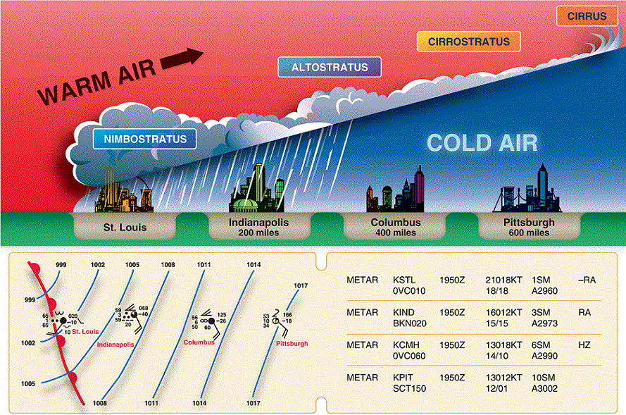
If you are wondering how to classify these types of clouds, they are actually fairly easy to distinguish. The following picture shows cirrus clouds: These clouds are wispy high clouds (generally over 20,000 feet) and usually the first to appear ahead of an approaching system.

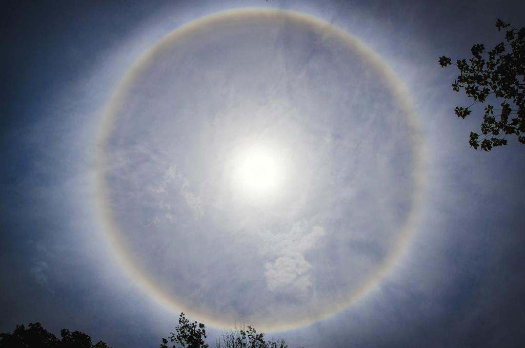
Next and usually coinciding with the cirrus clouds are cirrostratus clouds which are more widespread but seemingly transparent. These clouds are also found above 20,000 feet but are thicker and more sheet-like. One way to distinguish these clouds would be from the appearance of a halo around the sun or moon. As the night observer, these clouds are tough to identify sometimes because I can still see stars although they appear a bit more faint. The halo around the moon is the biggest giveaway to the presence of a high cirrostratus cloud layer.
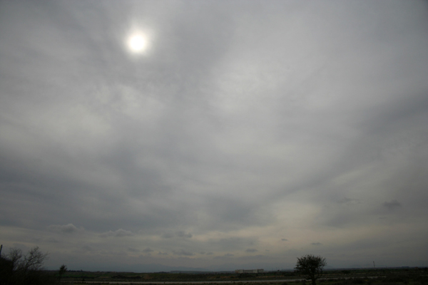
As the cloud deck lowers furthermore we find altostratus clouds. Altostratus clouds are midlevel clouds that typically cover the whole sky. They are generally found between 6,500 and 20,000 feet and will occasionally coincide with light precipitation. A way that I distinguish these clouds is when it looks like the sun or moon is visible through frosted glass.
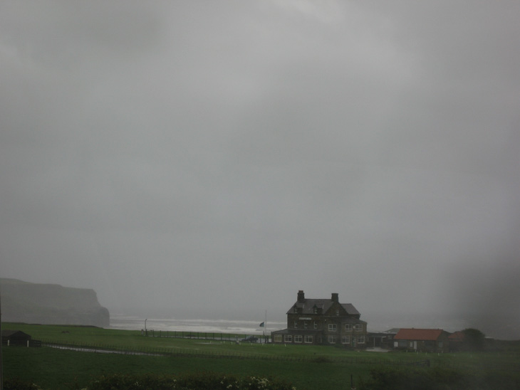
Finally, upon the arrival of the worst of the storm, clouds would transition to nimbostratus clouds. Contrary to popular belief, this is not the name of your favorite Wizard’s Broom from Harry Potter. These clouds are found below 10,000 feet and they are opaque and associated with widespread moderate to heavy precipitation.
Clouds can give us a wealth of knowledge on the weather to come and I find this a fascinating part of being a Weather Observer on the summit of Mount Washington.
Looking ahead, not at clouds, but instead at the weather forecasting models, the heat is about to CRANK. The monthly record high temperature for February is 43°F which was set in 1981 and tied in 1999. Tuesday and Wednesday may feature two consecutive days where highs could surpass this number as very warm air streams into the northeastern United States between an approaching system from the west and strong high pressure centered off the eastern seaboard. Current model indications show potential high temperatures Wednesday soaring to 48 degrees! WHOA, that’s a warm temperature! Relative to Mount Washington at least… In February…
Caleb Meute, Weather Observer/Staff Meteorologist

Seek the Peak Spotlight: The Cloud Chasers
Seek the Peak Spotlight: The Cloud Chasers By MWOBS Staff Mike Bergeron and Desiree Bolton have been participating and volunteering for Seek the Peak for three years now. Together, they comprise Team Cloud Chasers

Celebrating 250 Years: The Declaration’s Legacy in the White Mountains
Celebrating 250 Years: The Declaration's Legacy in the White Mountains By Peter Crane We are now approaching July Fourth, Independence Day, the day when we celebrate the adoption of the Declaration of Independence in

Seek the Peak Spotlight: Ryan Shepard
Seek the Peak Spotlight: Ryan Shepard By MWOBS Staff Before Ryan Shepard moved to Conway, he was in Western New York celebrating his 40th birthday party. “I wanted to go big,” he said. “Big”
