
Warm Weather Ahead!
2015-12-07 14:57:47.000 – Adam Gill, Summit Intern
It has been warm here in New England so far this December! The question is, will this warmth continue for a little while longer? The answer is yes for at least the next couple of weeks as a typical El Nino weather pattern sets up across the country. The warm waters in the Eastern equatorial Pacific Ocean causes warmer air to reside further north in the pacific than normal. This changes the path of the polar jet stream and the subtropical jet stream causing them to shift further north over the central and eastern pacific. This will displace colder air over Alaska and western Canada into the western US creating a trough. The atmosphere will always try to reach equilibrium so with cold air moving south will have to be equalized with warm air moving north. Warmer air will be displaced north out ahead of this trough creating a ridge over the eastern half of the US keeping us in the warmer weather.
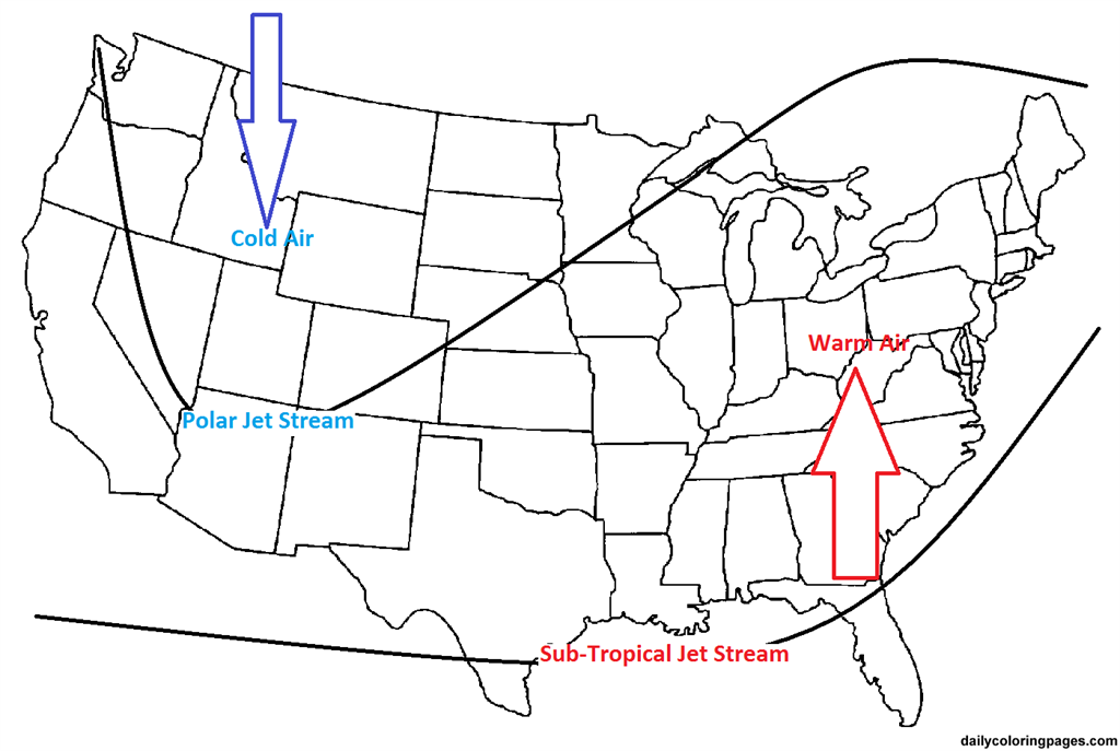
Looking ahead at our weather later this week into next weekend, we can see a good example of this weather pattern.

This pattern will usually mean stormy weather on the west coast with plenty of mountain snow, so if you want to ski, head west! Storms will still be able affect the east coast but because we are in the warm sector, so most of the precipitation will fall as rain. It is looking like the western trough will persist for at least the next 10 days and may be a bit longer which means temperatures will largely stay above average. There will likely be a few storms that would bring some colder air but the cold snaps will not last long.
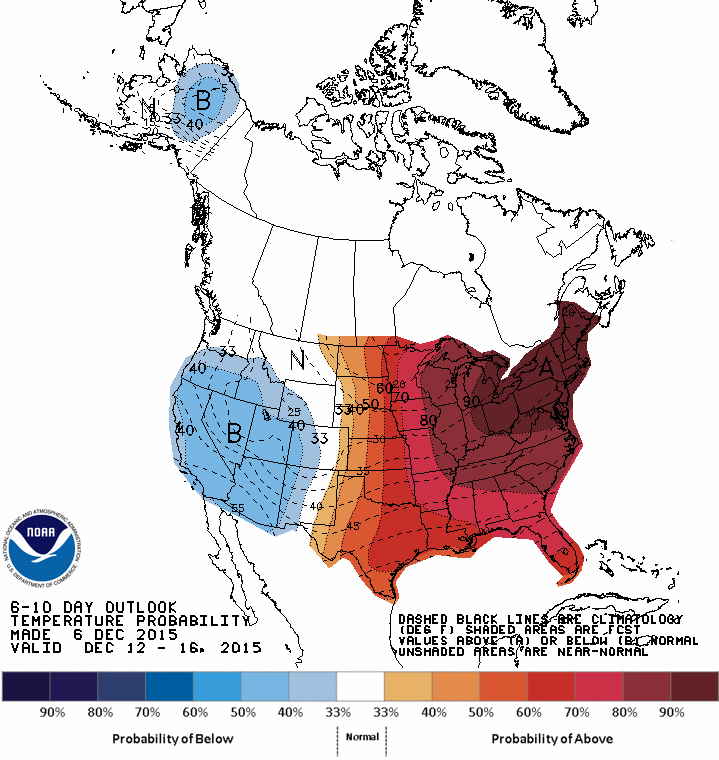
This map shows the probability of temperature anomalies and with a 90% chance of above average temperatures for the next 10 days; we can expect winter will not be arriving in New England for at least the first half of December.
Now, even though there is a strong El Nino, it does not mean this type of pattern will last the whole winter or even into the second half of December. There are many different factors that affect the storm tract so we could still see a few Nor-Easters affect us and some cold air outbreaks but it will be more likely those will be short lived events this winter. Up here on the summit, we could still see quite a bit of snow because the warmer air will be able to hold more moisture!
Adam Gill, Summit Intern
My Fear of Weather Became a Love of Meteorology
My Fear of Weather Became a Love of Meteorology By Kaitlin Farrell Hello! My name is Kaitlin Farrell. I am one of the fall summit interns here at Mount Washington Observatory. I recently graduated
Ascending with High Winds
Ascending with High Winds By Alonso Lopez Hi! I am Alonso Lopez, one of four interns at Mount Washington Observatory from August to December, 2026. I was born and raised in the Dallas-Fort Worth
26th Annual Seek the Peak Recap
26th Annual Seek the Peak Recap By Drew Bush Members of the "Peak Potential" team gather at Pinkham Notch before hiking Mount Washington for the 26th Annual Seek the Peak. View more images. We’ve had