
Weekly Weather Summary 11/27-12/03
2011-12-04 20:31:40.000 – Rick Giard, Weather Observer / Education Specialist
Weekly Summary 11/27-12/3
WEEKLY WEATHER SUMMARYNov. 27th – Dec. 3rd
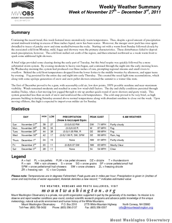
Continuing the recent trend, this week featured more anomalously warm temperatures. Thus, despite a good amount of precipitation around midweek totaling in excess of three inches liquid, snow has been scarce. Moreover, the meager snow pack has once again dwindled to traces of patchy snow and rime nestled between the rocks. Starting out with a warm front Sunday followed closely by the associated cold front Monday, mild, foggy and showery were the primary characteristics. These disturbances failed to deposit much precipitation, however. The cold front stalled out south of the region, and then returned northward as a weak warm front to spark some additional light showers.
A weak ridge provided some clearing during the early part of Tuesday, but this brief respite was quickly followed by a more substantial storm system. By evening moderate to heavy rain began, and continued through the night into the early morning hours. By Wednesday morning this system had produced over three inches of rain, prompting regional streams and small rivers to overflow. Behind the cold front temperatures dropped from the lower forties to the middle twenties by afternoon, and upper teens by evening. Fog persisted for the entire day and night into early Thursday. This created the usual light rime accumulations, which along with some upslope generation of snow and snow pellet showers returned the summit to a winter-like state.
The first of December proved to be a gem, with seasonably cold air, low dew points, 100% possible sunshine and near-maximum visibility. Winds remained moderate and resulted in some low wind-chill factors. The dry and chilly conditions persisted through midday Friday, when a fast-moving low jogged through to stir up another quick round of snow showers and gusty winds. This system generated less than an inch of snow and reinforced the cold temperatures. The cold snap proved to be very brief, as high pressure building in during Saturday ensured above normal temperatures along with abundant sunshine to close out the week. Upon moving offshore, this high is expected to import even milder air for Sunday.
Rick Giard, Weather Observer / Education Specialist

Seek the Peak Spotlight: The Cloud Chasers
Seek the Peak Spotlight: The Cloud Chasers By MWOBS Staff Mike Bergeron and Desiree Bolton have been participating and volunteering for Seek the Peak for three years now. Together, they comprise Team Cloud Chasers

Celebrating 250 Years: The Declaration’s Legacy in the White Mountains
Celebrating 250 Years: The Declaration's Legacy in the White Mountains By Peter Crane We are now approaching July Fourth, Independence Day, the day when we celebrate the adoption of the Declaration of Independence in

Seek the Peak Spotlight: Ryan Shepard
Seek the Peak Spotlight: Ryan Shepard By MWOBS Staff Before Ryan Shepard moved to Conway, he was in Western New York celebrating his 40th birthday party. “I wanted to go big,” he said. “Big”
