
Weekly Weather Summary December 11-17, 2011
2011-12-18 16:06:30.000 – Rick Giard, Weather Observer / Education Specialist
Weather Dec. 11-17
WEEKLY WEATHER SUMMARY
December 11-17, 2011
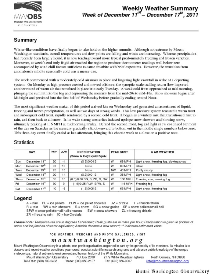
Winter-like conditions have finally begun to take hold on the higher summits. Although not extreme by Mount Washington standards, overall temperatures and dew points are falling and winds are increasing. Whereas precipitation had recently been largely liquid, it is now trending toward more typical predominately freezing and frozen varieties. Moreover, at week’s end truly frigid air reached the region to produce thermometer readings well below zero accompanied by wind chill factors sufficient to cause frostbite with brief exposures. However, the transition from anomalously mild to seasonally cold was a messy one.
The week commenced with a moderately cold air mass in place and lingering light snowfall in wake of a departing system. On Monday as high pressure crested and moved offshore, the synoptic-scale trailing return flow imported another round of warm air that remained in place into early Tuesday. A weak cold front approached at mid-morning, plunging the summit into the fog and depressing the mercury from the mid-20s to mid-10s. Snow showers began after Midnight and persisted into the first half of Wednesday before gradually ending around Noon.
The most significant weather maker of this period arrived late on Wednesday and generated an assortment of liquid, freezing and frozen precipitation, as well as two days of strong winds. This low pressure system featured a warm front and subsequent cold front, rapidly reinforced by a second cold front. It began as a wintery mix that transitioned first to rain, and then back to all snow. In its wake strong westerlies induced upslope snow showers and blowing snow, ultimately peaking at 116 MPH at midmorning Friday. Behind the second front, fog and light snow continued for most of the day on Saturday as the mercury gradually slid downward to bottom out in the middle single numbers below zero. This three-day event finally ended at late afternoon, bringing this chaotic week to a close on a positive note.
Rick Giard, Weather Observer / Education Specialist

Seek the Peak Spotlight: The Cloud Chasers
Seek the Peak Spotlight: The Cloud Chasers By MWOBS Staff Mike Bergeron and Desiree Bolton have been participating and volunteering for Seek the Peak for three years now. Together, they comprise Team Cloud Chasers

Celebrating 250 Years: The Declaration’s Legacy in the White Mountains
Celebrating 250 Years: The Declaration's Legacy in the White Mountains By Peter Crane We are now approaching July Fourth, Independence Day, the day when we celebrate the adoption of the Declaration of Independence in

Seek the Peak Spotlight: Ryan Shepard
Seek the Peak Spotlight: Ryan Shepard By MWOBS Staff Before Ryan Shepard moved to Conway, he was in Western New York celebrating his 40th birthday party. “I wanted to go big,” he said. “Big”
