
Weekly Weather Summary February 19th – 25th
2012-02-27 17:43:38.000 – Rick Giard, Weather Observer / Education Specialist
Weather Feb. 19-25
WEEKLY WEATHER SUMMARY
February 19th – 25th
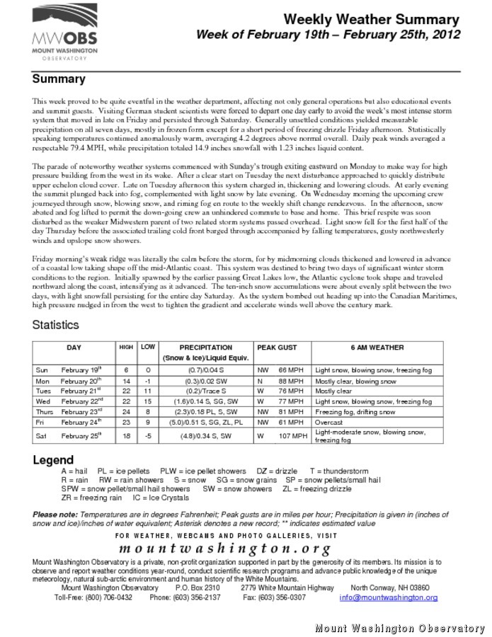
This week proved to be quite eventful in the weather department, affecting not only general operations but also educational events and summit guests. Visiting German student scientists were forced to depart one day early to avoid the week’s most intense storm system that moved in late on Friday and persisted through Saturday. Generally unsettled conditions yielded measurable precipitation on all seven days, mostly in frozen form except for a short period of freezing drizzle Friday afternoon. Statistically speaking temperatures continued anomalously warm, averaging 4.2 degrees above normal overall. Daily peak winds averaged a respectable 79.4 MPH, while precipitation totaled 14.9 inches snowfall with 1.23 inches liquid content.
The parade of noteworthy weather systems commenced with Sunday’s trough exiting eastward on Monday to make way for high pressure building from the west in its wake. After a clear start on Tuesday the next disturbance approached to quickly distribute upper echelon cloud cover. Late on Tuesday afternoon this system charged in, thickening and lowering clouds. At early evening the summit plunged back into fog, accompanied by light snow at late evening. On Wednesday morning the upcoming crew journeyed through snow, blowing snow, and riming fog en route to the weekly shift change rendezvous. In the afternoon, snow abated and fog lifted to permit the down-going crew an unhindered commute to base and home. This brief respite was soon disturbed as the weaker Midwestern parent of two related storm systems passed overhead. Light snow fell for the first half of the day Thursday before the associated trailing cold front barged through accompanied by falling temperatures, gusty northwesterly winds and upslope snow showers.
Friday morning’s weak ridge was literally the calm before the storm, for by midmorning clouds thickened and lowered in advance of a coastal low taking shape off the mid-Atlantic coast. This system was destined to bring two days of significant winter storm conditions to the region. Initially spawned by the earlier passing Great Lakes low, the Atlantic cyclone took shape and traveled northward along the coast, intensifying as it advanced. The ten-inch snow accumulations were about evenly split between the two days, with light snowfall persisting for the entire day Saturday. As the system bombed out heading up into the Canadian Maritimes, high pressure nudged in from the west to tighten the gradient and accelerate winds well above the century mark.
Rick Giard, Weather Observer / Education Specialist

Seek the Peak Spotlight: The Cloud Chasers
Seek the Peak Spotlight: The Cloud Chasers By MWOBS Staff Mike Bergeron and Desiree Bolton have been participating and volunteering for Seek the Peak for three years now. Together, they comprise Team Cloud Chasers

Celebrating 250 Years: The Declaration’s Legacy in the White Mountains
Celebrating 250 Years: The Declaration's Legacy in the White Mountains By Peter Crane We are now approaching July Fourth, Independence Day, the day when we celebrate the adoption of the Declaration of Independence in

Seek the Peak Spotlight: Ryan Shepard
Seek the Peak Spotlight: Ryan Shepard By MWOBS Staff Before Ryan Shepard moved to Conway, he was in Western New York celebrating his 40th birthday party. “I wanted to go big,” he said. “Big”
