
Weekly Weather Summary Jan. 8-14, 2012
2012-01-16 22:54:33.000 – Rick Giard, Weather Observer / Education Specialist
Weather Jan. 8-14
WEEKLY WEATHER SUMMARY
Jan. 8th – 14th
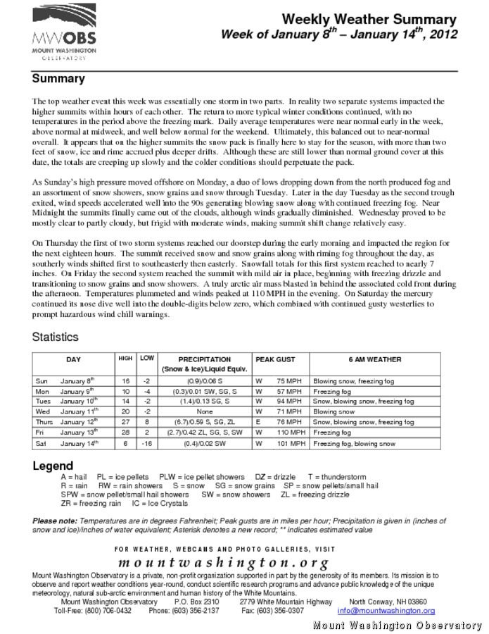
The top weather event this week was essentially one storm in two parts. In reality two separate systems impacted the higher summits within hours of each other. The return to more typical winter conditions continued, with no temperatures in the period above the freezing mark. Daily average temperatures were near normal early in the week, above normal at midweek, and well below normal for the weekend. Ultimately, this balanced out to near-normal overall. It appears that on the higher summits the snow pack is finally here to stay for the season, with more than two feet of snow, ice and rime accrued plus deeper drifts. Although these are still lower than normal ground cover at this date, the totals are creeping up slowly and the colder conditions should perpetuate the pack.
As Sunday’s high pressure moved offshore on Monday, a duo of lows dropping down from the north produced fog and an assortment of snow showers, snow grains and snow through Tuesday. Later in the day Tuesday as the second trough exited, wind speeds accelerated well into the 90s generating blowing snow along with continued freezing fog. Near Midnight the summits finally came out of the clouds, although winds gradually diminished. Wednesday proved to be mostly clear to partly cloudy, but frigid with moderate winds, making summit shift change relatively easy.
On Thursday the first of two storm systems reached our doorstep during the early morning and impacted the region for the next eighteen hours. The summit received snow and snow grains along with riming fog throughout the day, as southerly winds shifted first to southeasterly then easterly. Snowfall totals for this first system reached to nearly 7 inches. On Friday the second system reached the summit with mild air in place, beginning with freezing drizzle and transitioning to snow grains and snow showers. A truly arctic air mass blasted in behind the associated cold front during the afternoon. Temperatures plummeted and winds peaked at 110 MPH in the evening. On Saturday the mercury continued its nose dive well into the double-digits below zero, which combined with continued gusty westerlies to prompt hazardous wind chill warnings.
For the complete Weekly Summary along with daily statistics, please click on the link above.
Rick Giard, Weather Observer / Education Specialist

From Florida Heat to the Rockpile
From Florida Heat to the Rockpile By Alek Libby Hi everyone! My name is Alek Libby, and I am one of the summit interns here at Mount Washington Observatory this summer! I recently graduated

Summit Summer
Summit Summer By Aspen M. Hello everyone! My name is Aspen, I’m one of the summer weather interns here at the Mount Washington Observatory. I fell in love with weather at a young age
From the Sunshine State to the Home of the World’s Weather
From the Sunshine State to the Home of the World's Weather By Kristen Mihalcik Hello Everyone! My name is Kristen Mihalcik, and I’m one of the Summer interns here at Mount Washington. Enjoying
