What is a Wintery Mix?
2019-05-14 15:44:36.000 – Ian Bailey, Weather Observer/Education Specialist
We’ve reached the time of year where you may often hear phrases such as “a mix of precipitation” or even “a wintery mix of precipitation” in the forecast product you peruse. And you may find yourself wondering what exactly that means. Why can’t meteorologist just tell you that it’s going to rain or snow? Well, unfortunately, it’s a bit more complicated than that. Allow me to explain.
Precipitation forecasting is one of the more difficult tasks a meteorologist faces for a number of reason. Current technology has its limits, where even the best models can’t exactly predict how much precipitation is likely to fall. It becomes increasingly difficult in transition seasons like spring and fall, where atmospheric temperature profiles can vary drastically, with different levels of the atmosphere above or below the freezing mark. This can allow for a variety of precipitation types to occur in any given event. So let’s take a look at those different precipitation types and the temperature profiles where they are most likely to occur.
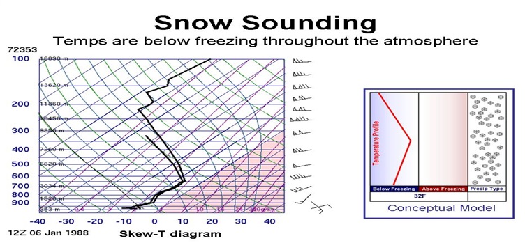
On the colder end of the list, we have snow. Plain and simple type of winter precipitation. Snowfall occurs when the majority, if not the entirety, of the temperature profile remains below the freezing mark. Snowflakes form in the Dendritic Growth Zone (DGZ) aloft and fall through an atmosphere that doesn’t allow the flake to melt. So when you have consistent snowfall, you can pretty much bank on a frozen temperature profile, such as this one:
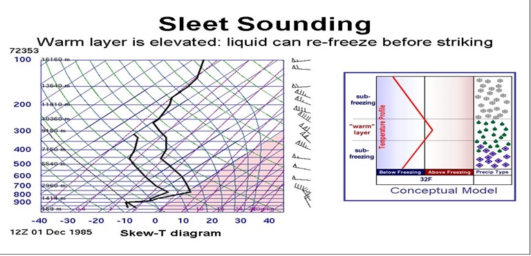
Then you get into the mix, including sleet and freezing rain. When you have sleet occurring, generally that means there is a section of the atmosphere aloft that is above freezing. Precipitation that falls into this region, solid or liquid, will warm up past the freezing point and for a brief period fall as rain. However, before it reaches the ground, it falls into a lower section of the atmosphere that is below freezing. And generally, this section is larger than the previous warmer one. Because of this, the droplet will freeze into a solid (or mostly solid) pellet before it hits the ground, classifying it as sleet.
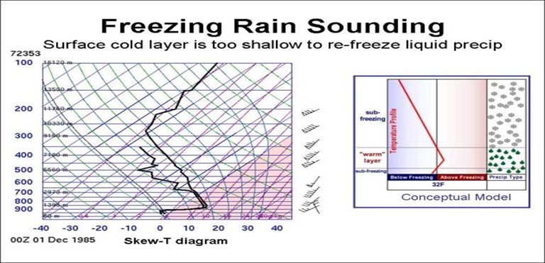
With freezing rain, the opposite is true. Precipitation will fall into a large section of warm air aloft and melt or mold into a droplet. That droplet will fall through a freezing layer before reaching the ground, however the freezing layer is generally shallow or small. As a result, the droplet reaches a “supercooled” state, much like the droplets that form rime ice here on the summit. The liquid will fall at or just below freezing, and once it hits the ground it is finally cold enough to freeze and form ice. This is why freezing rain events can be so nasty, as much of everything coated by the rain in such an event is inevitably frozen in ice.
And lastly, we have rain; the warmer end of the precipitation list. As the opposite of snow, rain occurs when the temperature profile is mostly if not completely above freezing. Fairly straight forward, since temperatures never cross the freezing mark the raindrop never has the chance to freeze, or rather it is completely melted into rain before crashing into the surface.
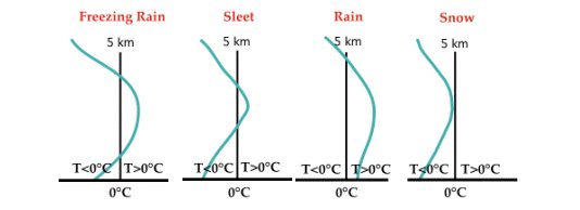
These four precipitation types are the “standard” types we witness during these transition seasons. The problem is, because of the general chaotic nature of the atmosphere and given that temperature is constantly fluctuating, there are times where you wont have just one of these precipitation types alone. Especially when you have frontal passages! For example, a warm front moving into a region of sub-freezing air can force precipitation that began as snow to transition to sleet, then to freezing rain and then to rain as the incoming warmer air flushes out the profile.
This can happen quickly or slowly. You can progress through all four types, or only a couple. As a result, it can often be very difficult to define exactly what type or types of precipitation you can expect. And when this occurs, meteorologist are prone to generalizing to cover all their bases, and define the forecast precipitation as a mix. That’s where the vernacular comes from and what it’s getting at. Given the behavior of the temperature profile in the coming hours, it is possible for you to see a mixture of snow, sleet, freezing rain, and/or rain.
So hopefully this clears the air a bit! It’s something that happens here on the summit often, given how much higher up in the atmosphere we reside and how dynamic the temperature profile can be. So the next time you see it pop up in our forecast products, you’ll be able to understand what we’re really getting at!
Ian Bailey, Weather Observer/Education Specialist
Three and a Half Months of Snow, Ice and Rime
Three and a Half Months of Snow, Ice and Rime, with Deeper Drifts. By Ryan Steinke Me outside on the summit near the Yankee Building. My internship with the Mount Washington Observatory
Supporter Spotlight: Righteous Vices Coffee Roasters
Supporter Spotlight: Righteous Vices Coffee Roasters By MWOBS Staff Righteous Vices Coffee Roasters, a local coffee roaster and shop located in Center Conway, New Hampshire, has been a partner of the Observatory since 2024.
Winter Storm Tracks Across New Hampshire
Winter Storm Tracks Across New Hampshire By Alex Branton As winter comes to a close, most of us are ready for the warmer temperatures and sunshine that come with Spring and Summer. Although we

