When Hail Freezes Over
2020-05-18 13:14:01.000 – AJ Grimes, Weather Observer
To coincide with this week’s Virtual Classroom topic of thunderstorm types, I wanted to explore a type of precipitation that is commonly found alongside thunderstorms – hail. It’s a fascinating phenomenon in meteorology, and, if you think about it, it seems a little strange to see pieces of ice falling from the sky on a hot summer day. Let’s start by taking a look at the interesting formation process of hail and what kind of conditions are needed to begin the process.
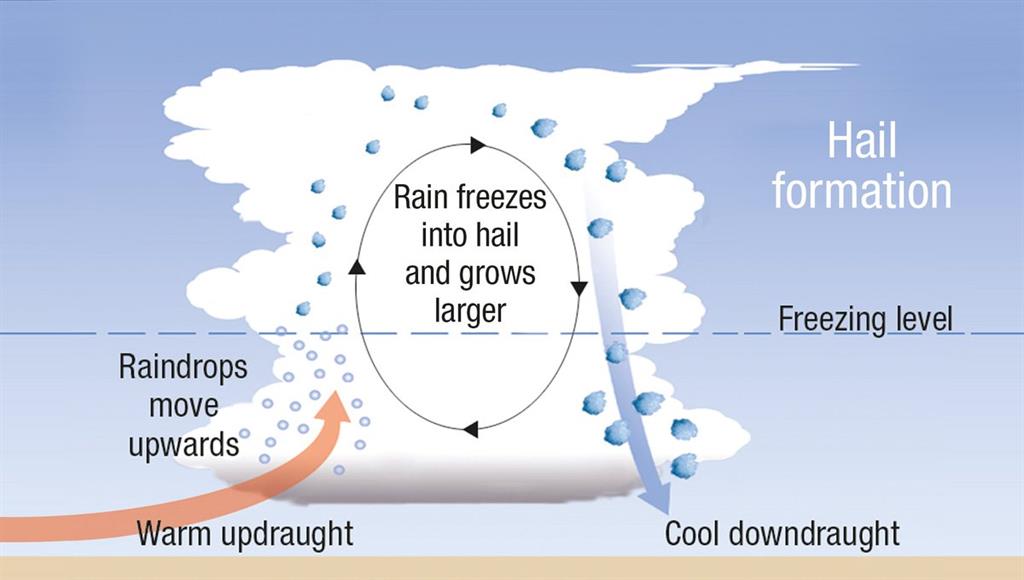
Hail is frozen precipitation that occurs when a strong updraft within a storm pushes rain drops higher within the cloud, where they freeze. This droplet is also pushed to different parts of the cloud by horizontal winds as it is kept aloft by the updraft. As it collides with water droplets (or other hailstones) that freeze onto it, it grows. The temperature in the cloud is the main factor that governs the appearance of the hailstones. When water freezes immediately upon contact with the growing hailstone, air bubbles don’t have time to escape, leaving a cloudy appearance to the ice (similar to why rime ice appears cloudy). If the water takes longer to freeze, air bubbles escape before the new layer is solid, leave a clear new layer of ice. With difference of temperature and other conditions within a storm cloud, hailstones may have multiple different-looking layers as they move within the cloud. When the hailstone is heavy enough for gravity to be stronger than the updraft, it falls to the earth.

The process of hail formation. Taken from the Australian Bureau of Meteorology.
The speed of the fall depends on several factors, including size. Hail that is between 1 and 1.75 inches in diameter may fall around 25-40 mph, but those greater than 4 inches may fall at speeds over 100 mph! In 2010, the largest hailstone recorded in the US fell in Vivian, South Dakota. It was 8 inches in diameter and just shy of 2 pounds in weight – that’s almost as big as a volleyball! Here on the summit, the hail we receive is small, typically around ¼ inch or pea-sized. We don’t usually see hail much larger than that because the mountainous terrain is unfavorable for the extremely tall thunderstorms with strong updrafts needed for large hail to develop.

Small hail piled up outside the Observatory.

A hailstone several inches in diameter, that clearly shows the aggregation of smaller stones as it moved through the cloud. Photo taken from NOAA.
Hail is dangerous for a few reasons. Besides its association with a severe thunderstorm, risks of lightning and high winds, significant damage can be caused by larger hailstones. They frequently damage crops, and often take a toll on vehicles (including airplanes) and buildings. Even small hail can accumulate on the ground, leading to slick driving conditions just like driving on ice. When a thunderstorm is approaching, you want to seek shelter immediately not only because of lightning, but to ensure you aren’t caught outside when the ice starts falling. To check out more on thunderstorms, including Tom’s presentation on the different types of thunderstorms, head to our Virtual Classroom page at mountwashington.org/classroom and stay tuned for more thunderstorm topics coming soon!
AJ Grimes, Weather Observer
Three and a Half Months of Snow, Ice and Rime
Three and a Half Months of Snow, Ice and Rime, with Deeper Drifts. By Ryan Steinke Me outside on the summit near the Yankee Building. My internship with the Mount Washington Observatory
Supporter Spotlight: Righteous Vices Coffee Roasters
Supporter Spotlight: Righteous Vices Coffee Roasters By MWOBS Staff Righteous Vices Coffee Roasters, a local coffee roaster and shop located in Center Conway, New Hampshire, has been a partner of the Observatory since 2024.
Winter Storm Tracks Across New Hampshire
Winter Storm Tracks Across New Hampshire By Alex Branton As winter comes to a close, most of us are ready for the warmer temperatures and sunshine that come with Spring and Summer. Although we


