Where does the weather come from?

2016-07-21 17:40:37.000 – Christopher Hohman, Summer Intern


When we’re in grade school we all learn about the beautifully simple water cycle as the explanation to every storm forming over us. This model for weather isn’t incorrect by any means, but you’d be surprised how much more there is to the whole process. On a daily basis the atmosphere moves like a fluid on not just small local scale, but continental and even global. This is one of the most core ideals of meteorology, and after staring at pressure charts for long enough and even observing in the field, one can start to get a good grasp on this concept. So while there are many different processes, I’ve decided to focus on one extremely common way we experience simple forms of weather like rain and thunderstorms: low pressure systems.
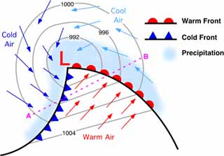
Everyone has heard of them, they’ve seen the long blue lines with triangles on them and the red ones with half circles as well. While they seem kind of scary and tricky to understand, they’re actually fairly simple and can explain a lot of the weather you see in your neighborhood. So the first question really is “What is a low pressure system?” Low pressure is simply a location in the atmosphere that is experiencing below average pressure. This can be due to a number of different reasons, but not going too deep into why, they tend to form in the leeward side of the Rockies in America. These systems do not move like a car driving directly to a location, they are fluid and move corresponding to what other systems are occurring around them. A critical attribute of low systems are the way the winds flow around them. Low pressure systems flow in a “cyclonic form.” That sounds kind of cryptic, but really the winds just spin in a counter-clockwise way about the center of the low. This is critical for knowing what types of fronts are associated with the low. Here’s a picture to visually see it:
 
 
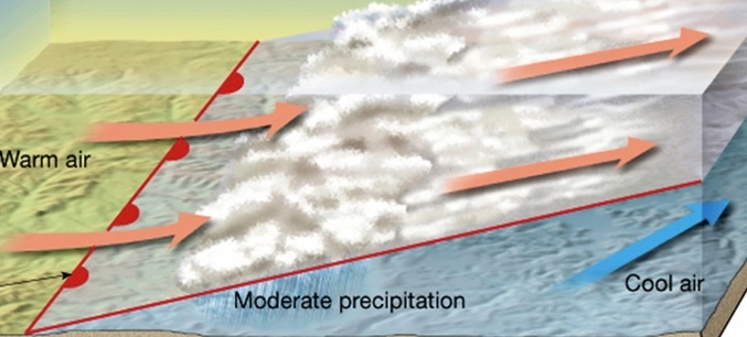
To start and tie this all together, let’s focus on the fronts. To start the warm front is the red half circles located to the right of the center of the low. Warm air is less dense, and has a more gradual slope, allowing moisture to flow up this “ramp” and form rain! These showers usually form more steady and moderate precipitation in the area. These are in essence your rainy days. 
 
 
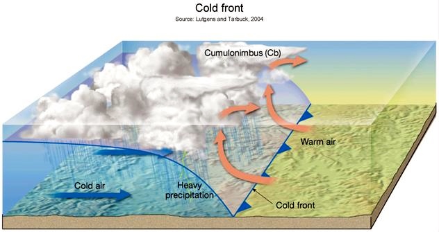
Cold fronts on the other hand are denser and have a sharper incline of temperature change. Due to this, the cold air acts like a bulldozer pushing up warm moist air and forming tall cumulonimbus clouds; also known as thunderstorms! This is typically why things tend to cool off right after a strong thunderstorm.  
 
 
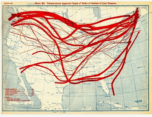
This idea of the two fronts associated from a low pressure system is an extremely common way for one to see precipitation in an area. The question is, how does this have to do with Mount Washington? Well if you take a look at the 30 year average track for low pressure, it’s easy to see how often we see systems glide over us 
 
So next time the forecast calls for a stormy weekend or a severe thunderstorm heading your way, check your neighborhood and see what fronts are heading your way! I tend to use this site: http://www.wpc.ncep.noaa.gov/html/sfcloop/radsfcus_exp_test.html

Thanks for reading! See you next week.


Christopher Hohman, Summer Intern

My Summer Internship Recap

September 5th, 2024|Comments Off on My Summer Internship Recap

My Summer Internship Recap By George Mousmoules It is hard to even begin to describe all that has happened in the last three months during my time at Mt. Washington. Between writing my first

Reflecting On My Summer in the Clouds

September 4th, 2024|Comments Off on Reflecting On My Summer in the Clouds

Reflecting On My Summer in the Clouds By Maya Hartley Arriving at the summit of Mount Washington for the first time ever just a couple of months ago was a moment I will never

Find Older Posts