Why the East Wind Busted my Forecast and The Reason for the Rapid East to West Wind Shift for Thursday’s Low
2020-03-02 17:29:10.000 – Caleb Buchler, Summit Intern
Our shift started off with winds less than five mph! I found it hard to believe the next day we would be experiencing gusts around the century mark. Mount Washington made me forget how quickly it can change its mood. On Wednesday, while creating my forecast with our new observer Dave, I explained to him that strong winds out of the East are often gustier than our predominant winds from the Northwest and West. This is essentially due to a steeper topography to our East as Ian had explained on my first shift. I had never actually experienced a powerful East wind on the summit before. This would explain why my forecast for winds was a bust on Thursday morning! After looking at Model Output Statistics for the NAM and GFS products for projected winds along with a long analysis of different models, I determined it was safe to go higher than the models and predict 60 to 80 mph with gusts up to 100 mph. A part of me was saying that I should have raised the potential gusts to 110 mph, but I was hesitant to get too aggressive on a forecast I was not familiar with. Either way I determined my forecast was going to be a good indication with winds, snow, and visibility that it would be very unsafe to visit the summit.
When Thursday morning came around and I was grabbing my morning coffee, I saw our home page in the living quarters registering average wind speeds around 90 mph! Once I was up in the weather room, we felt the building tremble from a big gust. The Hay’s chart spiked and our pitot tubes registered a gust of 132 mph around 6:30am! Forecast busted. At that moment, I truly understood why Easterly winds are so challenging to predict. I will take this lesson with me for the next time we expect strong East winds and I am forecasting.
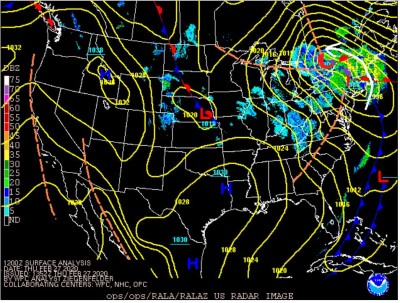
This brings me to understanding why those East winds suddenly shifted to West on Thursday. First, I think it is important to note that this winter has seen unusual storm tracks with the center of most low pressure systems staying to our West. The storm tracks are driven by the jet stream which has not experienced many deep troughs positioned to our East over the Atlantic. Because of this, we have not had as many classic Nor’easters developing off the Mid-Atlantic dumping, mainly snow on the Northeast. Low pressures are known to have winds sucked towards their center in a counter-clockwise manner. With this system rapidly intensifying as it headed straight North from the Great Lakes, we were on the warm, Eastern portion of the storm. On the East side of these lows, the airflow pattern brings warm coastal moisture into the Whites (just like this one). That is why temperatures were above average with lower elevations receiving plenty of rain and mixed precipitation. The summits were in the mid-20s with a heavy wet snow, dumping 9.5 inches of snow on Thursday alone. This was the same time when we experienced a gust of 132 mph.
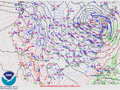
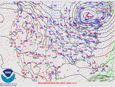
Why the wind switch though? We had winds drop below 10 mph early in the afternoon then quickly increase to 70 to 90 mph by that night. However, now they were out of the West! As I said earlier, the storm track kept the center of the low to our West as it took a track nearly due North. As the center of the low passed over us, winds calmed down significantly. Once it passed over and to our North, the winds went West. This brings us back to the concept of winds wrapping around a low pressure counterclockwise. We were now on the Southern portion of the system. Winds were now wrapping around the center, sucking cold air down from the North then to the West into New England. Temperatures dropped quickly as a completely different air mass was being pushed into the region. That is why we often see cold Northwest winds quickly follow on the backside of Nor’easters, especially on the coast.
Next time we have a deep low pressure hit the region, pay attention to that wind shift after the storm passes through! I only advise you not to be on Mount Washington for it!
Caleb Buchler, Summit Intern
Three and a Half Months of Snow, Ice and Rime
Three and a Half Months of Snow, Ice and Rime, with Deeper Drifts. By Ryan Steinke Me outside on the summit near the Yankee Building. My internship with the Mount Washington Observatory
Supporter Spotlight: Righteous Vices Coffee Roasters
Supporter Spotlight: Righteous Vices Coffee Roasters By MWOBS Staff Righteous Vices Coffee Roasters, a local coffee roaster and shop located in Center Conway, New Hampshire, has been a partner of the Observatory since 2024.
Winter Storm Tracks Across New Hampshire
Winter Storm Tracks Across New Hampshire By Alex Branton As winter comes to a close, most of us are ready for the warmer temperatures and sunshine that come with Spring and Summer. Although we

