
Winter Hiking Hazards: Cornices
2018-03-25 14:24:25.000 – Taylor Regan, Weather Observer
From our perch atop New England, summit staff are often treated to some pretty neat views. On a crystal clear day, these views extend for 130 miles, as far away as Mount Marcy in the Adirondacks to our west and all the way to the Atlantic Ocean to the east. Today though, I want to talk about a phenomenon spotted just a few miles from us on the summit, and that is a snow cornice.
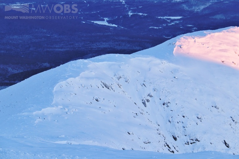
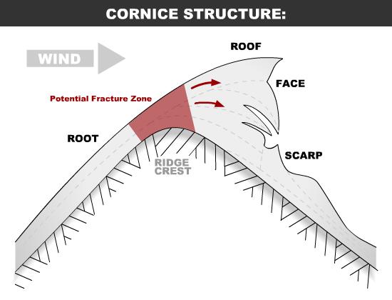
First off, what is a snow cornice and how does it form? A cornice is essentially a buildup of snow that is deposited by the wind onto the downwind side of an obstacle, in this case, the ridgeline along Mt. Clay. Cornices vary in size and can range from just a few feet in height to areas much larger than the size of a house! Cornices need two things to develop: wind and snow. The wind must be strong enough to move and deposit snow, but not so strong as to completely scour the surface. Speeds of 15-25 mph are ideal.
Why are cornices dangerous? A cornice poses a real mountaineering and/or backcountry skiing hazard for a variety of reasons. Cornices are typically very difficult to identify from the top of a ridgeline because they often look as though the ground simply continues on underneath them, even though the snow is actually just built up on itself. Additionally, they are very susceptible to sudden fractures and extremely sensitive to triggers (such as the weight of a hiker or skier). The collapse of a cornice can also trigger large scale avalanches in the terrain below.
While it is relatively easy to spot cornices when skies are clear and you are observing the terrain from a distance, they become much more difficult to distinguish when you are hiking along a ridgeline or are enshrouded in fog. As a note of safety, never assume a cornice will be able to support your weight, and keep in mind that snow and cornices will build up and develop on the leeward side of a ridge. Determining the leeward side of a ridge however, keeping in mind that winds can and do shift directions, can be difficult, especially when visibility is compromised.
The Mount Washington Avalanche Center (www.mountwashingtonavalanchecenter.org) produces a daily avalanche forecast that I encourage anyone interested in backcountry exploration to check out. Additionally, their website provides a host of information regarding navigating terrain in the safest manner possible, as well as other educational resources regarding snowpack and making smart hiking/skiing decisions in the backcountry.
Taylor Regan, Weather Observer

Seek the Peak Spotlight: The Cloud Chasers
Seek the Peak Spotlight: The Cloud Chasers By MWOBS Staff Mike Bergeron and Desiree Bolton have been participating and volunteering for Seek the Peak for three years now. Together, they comprise Team Cloud Chasers

Celebrating 250 Years: The Declaration’s Legacy in the White Mountains
Celebrating 250 Years: The Declaration's Legacy in the White Mountains By Peter Crane We are now approaching July Fourth, Independence Day, the day when we celebrate the adoption of the Declaration of Independence in

Seek the Peak Spotlight: Ryan Shepard
Seek the Peak Spotlight: Ryan Shepard By MWOBS Staff Before Ryan Shepard moved to Conway, he was in Western New York celebrating his 40th birthday party. “I wanted to go big,” he said. “Big”
